Figures:
1235/1056 East profile
1235/1056 West profile
1235/1056 North profile
1235/1056 South profile
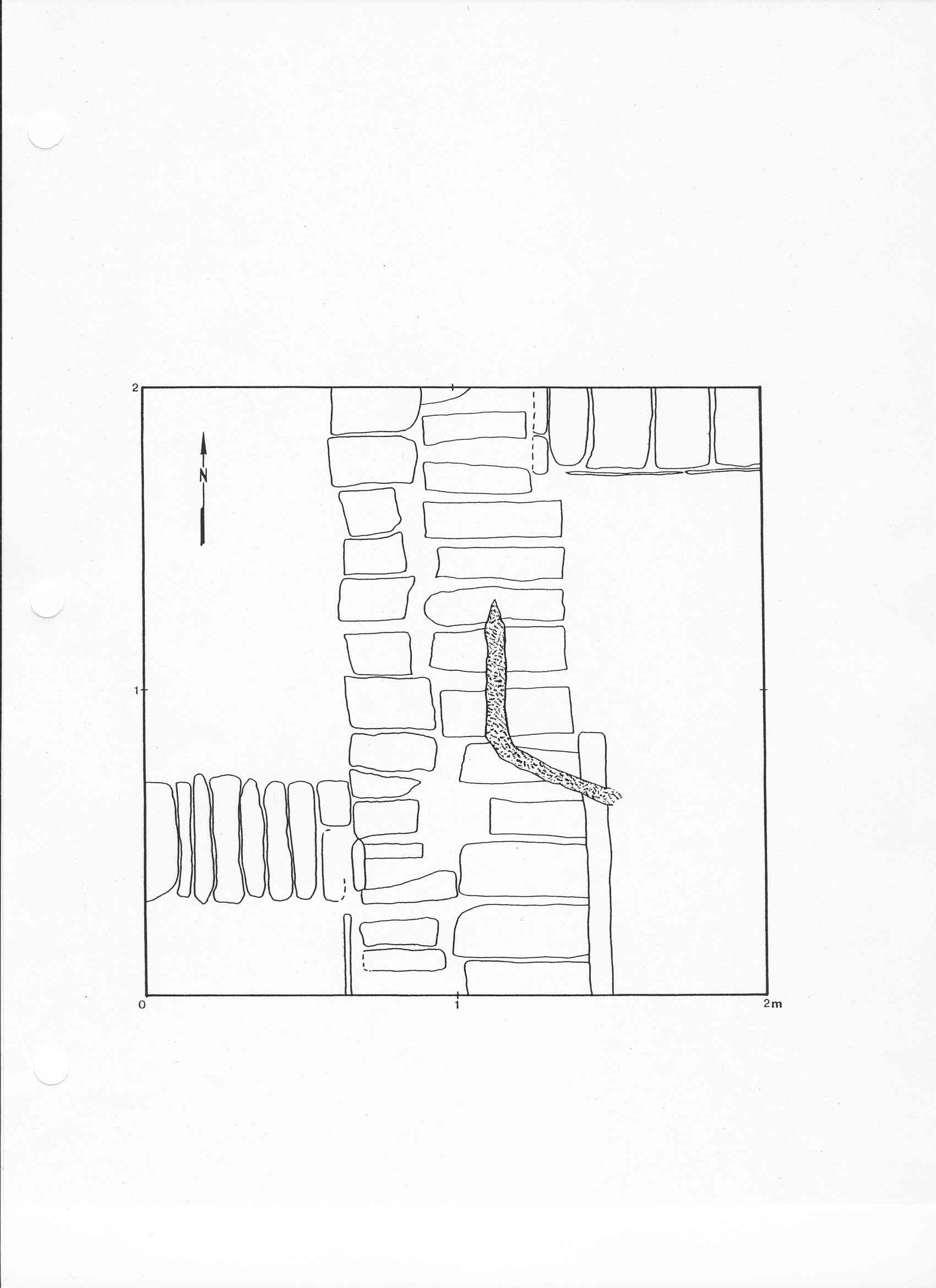
1235/1056 Main walls floor plan
The stratigraphy in this unit is extremely complex, with substantial mud brick walls, floors, pits and other features. Most of the volume of 1235/1056 was occupied by mud brick walls that traversed the unit from approximately north to south and east to west. These walls were substantially rebuilt at various times and are associated with long-term continuous occupations. In the lowest levels we found courses of brick (Figures: No captions on figures so perhaps these should be dropped?) that may be remnants of a phase of construction unrelated to the other exposed mud brick walls in this unit.
Our excavations defined the stratigraphic levels illustrated in Figures 1235-1056-05-7.jpg with each level comprising one or more sedimentary units.
Stratum I comprises a silty sand intermixed with numerous decomposing fragments of pottery, especially in the salt crust toward the upper portions of the unit (the Upper Pottery Layer, or UPL). The boundary of Stratum I and Stratum II is quite distinct in that Stratum II has a much higher clay content. Stratum II also contains some areas of apparently water-laid clays. Stratum III, in contrast, is mainly sand and contains almost no silt or clay.
Stratum IV is a very dark brown medium sand with quartz granules containing numerous sherds, charcoal bits, and mottles identified as mud brick fragments. Stratum IV is a major unit that is evident in all four walls of the excavations. This is a very thick unit (up to 30 cm in places) and seems to represent a combination of wall collapse and dump deposits. Several of the larger sherds are horizontally bedded and some minor laminations are present as well.
Stratum VII is a silty sand with little silt or clay containing many dark grayish brown (2.5Y 4/2) brick fragments and abundant large sherds. The excavator described this as being a well-defined pit structure that sloped slightly to the southeast. Based on the presence of brick fragments, charcoal fragments, and relatively abundant ceramics and bone, its contents may be wall collapse along with some redeposited building debris. Its boundary with Stratum IV is clear and distinct. Stratum VI contains mainly sand, little silt or clay, and many large sherds. Stratum X is a layer of silty sand and large sherds and is found in the north and west walls only. It may be a subunit of Stratum IV. Stratum VIII is similar in composition to Stratum X in that it was mainly silty sand containing large sherds.
Stratum IX is a substantial layer of silty sand with large sherds in locally dense concentrations, as well as brick fragments indicative of wall collapse and some dark areas suggestive of organic refuse. This unit forms a capping deposit between the dark fill from above and stratigraphically older wall collapse and rubble below.
Stratum XI is composed mainly of decomposed bricks all of fairly small size and rounded, and having little apparent internal stratification. It is distinguished from Stratum XII only by the latter’s slightly darker color. Stratum XIII seems to be mainly decomposed mud brick, primarily of the gezira bricks – those made of light-colored, homogeneous sands and gravels – as well as some of the more clayey brown bricks. There are few sherds in this stratum, and it probably represents wall collapse or redeposited building debris.
Stratum XIII represents the final capping deposit covering the entire square. Below this the deposits are differentiated into two main areas on opposite sides of two walls defined as SUs 18 and 39. These two sequences are both directly associated with this large wall and can be, roughly, divided into eastern and western portions ([Cagle, 2003 #720]:62).
West portion (Area B in [Buck, 1990 #249]; Strata XIV, XV, XI, XXII, XXIII, XXVII, XXVIII)
Stratum XIV is a small deposit in the southwest corner of the square and is mostly clean sand with few artifacts or brick pieces. Stratum XV is probably the occupation surface associated with the major room walls in this area of the square and corresponds to SUs 34 and 35 (Cagle 2003 interpreted SUs 28, 32, 34, 35, 38, 40 as all belonging to the occupation surface). It is composed of a dark grayish brown silty sand with rare laminated patches and substantial clay, rare sherds, and no brick pieces. The laminations consist of alternating bands of dark brown and lighter yellow layers with the darker layers containing some charcoal flecks. This series is interpreted as several occupation surfaces separated by clean sand. The deposits in this Stratum are separated by a small partition wall (SU-39) but the lower deposits connect underneath it.
Below this are five additional strata (XXI-XXIII, XXVII, and XXVIII) that are interpreted as various forms of wall collapse deposits (see Buck 1990: 151-152 and Cagle 2003:62-63). The lowest portion of Stratum XXVII (SU-48) was described by the excavator as a prepared plaster surface as it curved up to com in contact with the base of the Stratum XV wall. East portion (Strata XVI-XIX, XXIV-XXVI): Stratum XXVIII represents the floor surface for this room and is covered by Strata XVI and XVII that may represent either a prepared floor with some dump material within it, or some form of one or the other. Structurally, Stratum XXVIII is very similar to Stratum XV on the other side of the wall: laminated layers of dark brown material separated by lighter clean sand layers.
The remaining strata are a combination of wall collapses, with the exception of Stratum XXVI which makes up the basal deposit of the entire square and is composed of unstratified silty sand and is either some sort of fluvial deposit or more probably a prepared sand surface (see Buck 1990:152 and Cagle 2003:63).
In sum, 1235/1056 contains the following basic sequence: a set of capping deposits composed of a combination of UPL, wall collapse, and small dump deposits, some contained within a shallow excavated pit; two sets of fairly thick, stratified floor deposits (Strata XV and XXVIII) resting at about the same elevation and relation to the wall; and a set of basal deposits of largely wall collapse and a prepared sand surface.
Two building episodes are represented in this square, the later one represented by the floor deposits associated with the walls visible in the profile drawings. The floors of these occupations are 40-50 cm thick and probably represent fairly continuous occupation of the structure(s). An earlier building episode is visible underneath the prepared sand floor but this was not excavated due to the high water table.
Regarding the distribution of artifacts and biological remains in 1235/1056, there is little apparent contrast with the remains found in other units. A relatively large number of fish remains were found in SUs 7 and 8, Strata IV, V, VI, and VII. Figure (prob. N profile) shows that these fish remains are part of redeposited materials not directly associated with the in situ architecture in this unit, and these could come mainly from just a few individual fish since the number of identified specimens (NISP) is the measure used. The ceramics included numerous examples of Types 3 and 11 – both of which are crude vessels that appear to have been the mainstays of domestic food storage, preparation, and cooking. The lithics also are of the same types and distribution as in most of the other excavation units.
In short, 1235/1056 is probably an area of the site in which two or perhaps three ocational periods there were small mud brick buildings of the type common in Egyptian villages for many millennia.