4.0 Materials and methods.
4.1 Materials
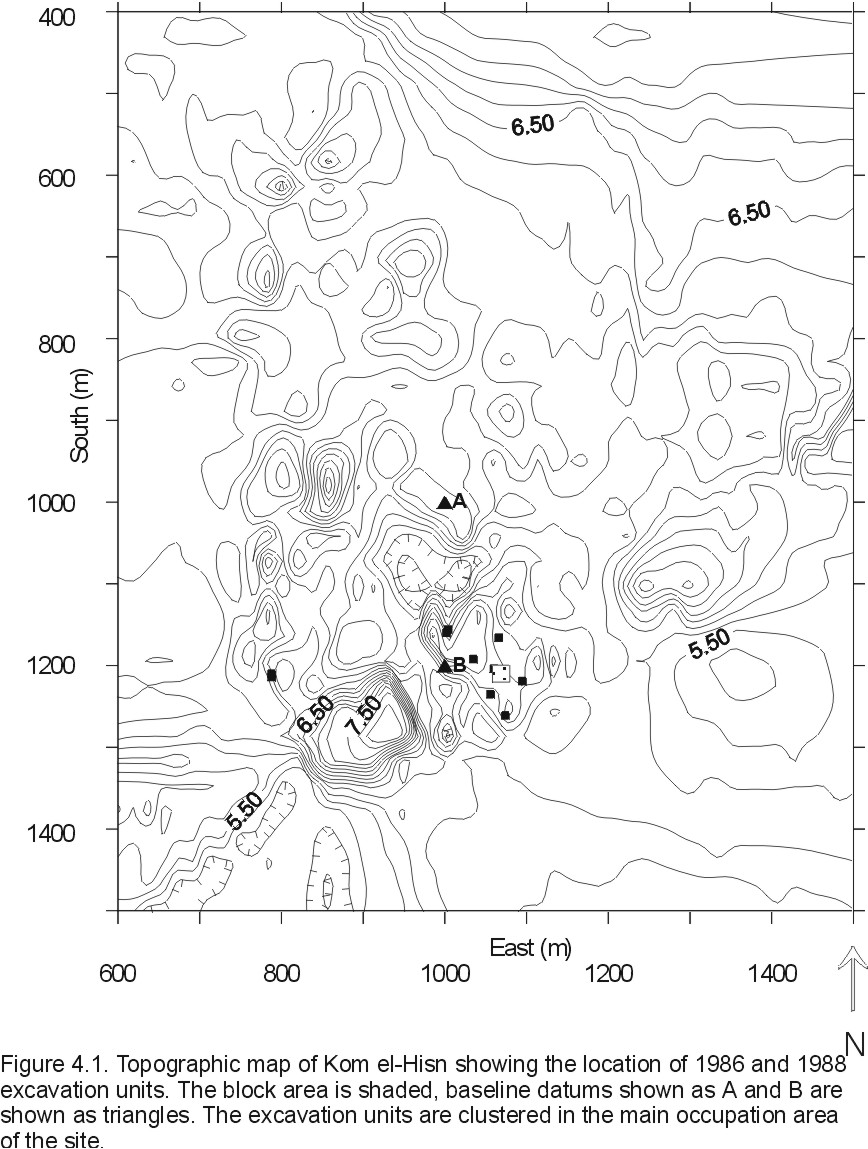
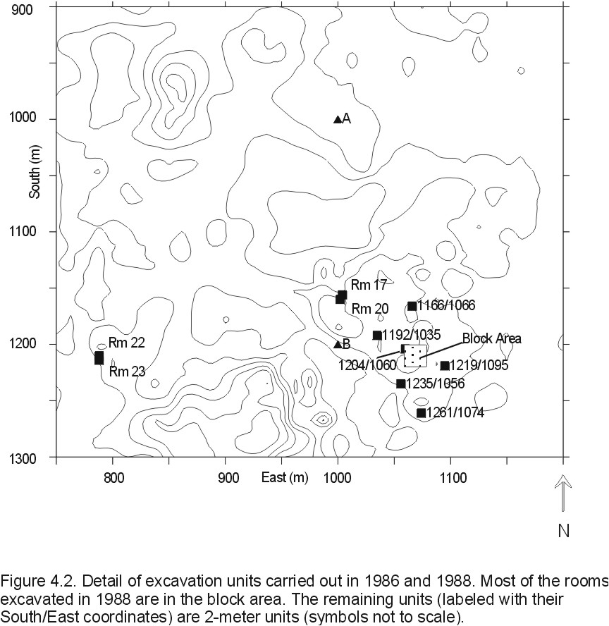
The most recent excavations at Kom el-Hisn were carried out over three seasons, 1984, 1986, and 1988, of which only the latter two are used in this analysis (the 1984 season consisted of only mapping and excavating small test pits). Data from the 1986 season consists of several 2-meter units placed according to a stratified random sample design. In addition, a shallow trench called the 'block area' was also excavated in contiguous 2-meter units covering 72 m2 (see Figures 4.1 and 4.2). Based on preliminary analyses of the 1986 data three areas were chosen for wider excavation in 1988. The architecture in these areas lies close to the surface and was exposed by scraping off the upper 10-20 cm of upper pottery layer (hereafter, "UPL"), a widespread stratum of salt-encrusted ceramics in a reddish matrix resulting from sebakhin digging. Structures identified as such were then excavated as individual rooms and were numbered sequentially. Several of the rooms excavated in 1988 were also partially excavated in 1986 as part of the block area. In these cases, any of the 1986 deposits that correlated with 1988 room structures were added to the 1988 room deposit sequences.
In both seasons, excavation was carried out following natural stratigraphy. The basic unit of excavation was the 'sedimentary unit' or SU. The SU was defined to be a sedimentary structure that differed from the surrounding sediments in compositional characteristics (color, content, structure, texture, etc.) and extent. Ideally, each SU could be considered a separate depositional event; in practice, the excavator often noted that what initially appeared to be separate units were actually variable portions of larger units.
I have chosen to create an additional analytic unit that is a superset of the SU called the 'depositional unit', hereafter referred to as the "DU". The DU represents a larger unit consisting of one or more SU's that together are thought to represent a single depositional event. I defined each DU by studying the excavation notes, profile and plan drawings, and noting the artifact densities for each SU and then lumping together SU's that seemed to be part of larger depositional units. The DU thus represents the basic unit of analysis for this study and all artifacts contained therein are assumed to have been deposited by the same processes and owe their contemporary position in space to those processes.
Each DU is part of the stratigraphic profile of an excavation unit and is designated by the coordinates defining the excavation unit in which it occurred, the room number (if applicable), and the DU number. The DU number roughly corresponds to its position in the profile from top to bottom (DU-1 nearer the surface). For 1986 units, the coordinates defining the unit are the southwest corner of the excavation square. For 1988 units (rooms) these coordinates are an arbitrarily chosen datum stake near to and outside of the southwest corner of the room structure. Coordinates are in meters south and east of the origin of the grid system (to the northwest of the site). A typical DU designation will appear thus: 1214/1062r12du01, meaning the unit lies 1214 meters south, 1062 meters east, is designated as Room 12, and DU-1. All 1986 units have as default room '00' and are differentiated by their S/E coordinates.
The volume of each SU was determined by the number of baskets of a predetermined volume that were removed. All material (except where noted by the excavator) was dry screened through approximately 1/4" mesh and all artifacts were removed and bagged separately at the screens. Faunal material (bone and shell) was identified to species or element if possible and weighed. Ceramics were separated first by diagnostic type (rims, bases, etc.) and body sherds, the latter being further sorted by fabric type (Nile A, B, and C) and each fabric type weighed. Diagnostic sherds were sorted by type, a detailed description of which is in Chapter 6. Lithics were weighed in aggregate and then analyzed typologically. In addition, at least one sediment sample and one flotation sample were also excavated and bagged separately.
4.2 Deposit characteristics
The basic unit of analysis used here is the deposit which is defined as a group of sedimentary particles that were brought together by similar processes over a given period of time. The only analytically definable relation that the included particles have with one another is that their final position in space was determined by these processes. These processes may be defined by the source of the individual particles, the mechanism by which the particles were transported to their final location, the type of depositional basin in which they were deposited, and any post-depositional alterations they may have experienced.
I have chosen to use two procedures to classify Kom el-Hisn deposits. First, I devised a paradigmatic classification based on five dimensions that would provide a baseline for comparison. Theoretically, a well-defined paradigmatic classification would separate the deposits unambiguously into different classes representing distinct modes of deposition. However, practical considerations necessitated a simpler grouping scheme that would accommodate the available data. Consequently, the initial paradigmatic classification was used as an initial basis of description and other, more interpretive factors, were then used to arrange the resulting classes into groups that represent general types of deposits such as wall collapse, dumps, etc. The factors used to generate these interpretive groups were based on sedimentary principles such as the orientation of particles and the overall structure of the deposit, not on common sense interpretations of their contents. Thus, the final groups still represent a geological definition of a deposit rather than an anthropological one.
The initial paradigmatic classification is based on that used by Buck (1990) and is composed of five dimensions: structure, texture, dominant large clast, occurrence of mud bricks, and the presence of burning. My dimensions have somewhat different definitions from Buck's because of different research goals and available data. Buck's analysis concentrated on site formation processes and was based on extensive compositional and grain size analyses on a small sample of deposits. My goal is a more general description of the spatial distribution of artifacts across a large number of depositional units with fewer detailed analyses of deposit composition apart from macro-scale properties.
The dimensions are as follows (the number in parentheses after each mode is the numerical code each mode was assigned):
Dimension I: Structure. Defined as the overall patterning of particles within the deposit.
Mode 1 (1): Massive: Homogeneous with respect to spatial orientation.
Mode 2 (2): Horizontal: Stratifications or laminations, indicative of cyclical variations of the same processes.
Mode 3 (3): Vertical: Generally used to define vertically placed courses of mud brick.
Dimension II: Texture. Defined as the predominant particle size, including artifacts.
Mode 1 (1): Coarse: Abundant gravel-sized (4mm) and up.
Mode 2 (2): Fine: Little or no gravel-sized objects.
Dimension III: Dominant large clast type. Only refers to gravel-sized and larger particles.
Mode 1 (0): None.
Mode 2 (1): Bricks, brick fragments, or mottles (decomposed brick).
Mode 3 (2): Ceramics.
Mode 4 (3): Other.
Dimension IV: Brick content.
Mode 1 (0): Absent.
Mode 2 (1): Fragments, mottles, or haphazardly placed whole bricks.
Mode 3 (2): In situ, whole (in situ brick walls).
Dimension V: Evidence of burning.
Mode 1 (0): No burning evident.
Mode 2 (1): Burning evident.
Mode 3 (2): Obviously in situ burning evident (e.g., hearths).
Dimension I, Structure, indicates the transport mechanism. Massive deposits were aggregated by similar processes acting on all size particles rather than cyclical variations indicated by horizontal structure. Vertical structure is used to denote standing mud brick walls.
Dimension II, Texture, also refers to the transport mechanism; specifically this dimension seeks to distinguish deposits by the relative energy of the transport medium. Deposits with large particles have a more competent transport mechanism than deposits with smaller particles; e.g., humans or gravity, as opposed to running water. Post-depositional accretions, such as caliche nodules, are not included. This dimension was difficult to determine in practice without detailed grain size analyses and was not used in the final analysis.
Dimension III, Dominant large clast type, seeks to identify possible sources of larger particles -- for example, bricks or brick fragments as opposed to building stone or ceramics. In most cases this dimension was either ceramics or brick. Since bricks constitute such large individual clasts, the presence of even a few bricks could overwhelm the amounts of any other material. Because of this, where ceramics and bricks were both present in quantity, ceramics were generally chosen to be the dominant clast unless bricks or brick fragments make up a majority of the entire deposit (such as wall collapses).
Dimension IV, Brick content, is used to determine the source of any brick particles present, whether they were deposited by humans directly (as whole, in situ bricks) or by some form of natural transport mechanism (wall collapse). This is an additional dimension not used by Buck and was included to specify the presence of bricks or brick pieces when another type of particle (usually ceramics) was designated as the large clast. It also serves to differentiate collapsed walls from in situ (standing) brick structures.
Dimension V, Burning, is used to indicate the source of the material (primarily hearths or other cooking features) and to specify whether the burning took place before (Mode 2) or after (Mode 3) deposition. Ash, charcoal, or charred artifacts in an otherwise non-burned matrix indicates pre-depositional burning while matrix that is obviously burned in situ (such as a hearth) indicates post-depositional burning.
I determined the value for each dimension by examining the excavator's field description of the deposit and the associated metric measurements of artifact densities (amount per unit volume of sediment). In most cases the appropriate modal value was clear. In others, some judgment was allowed due to either lack of adequate field descriptions or the unanticipated ambiguity of the dimension itself. Texture and dominant large clast type, for example, were difficult to determine without detailed grain size analysis of the sediment samples. Consequently, texture, while noted, was not used in the final set of analyses.
Once modal values were assigned, each deposit was defined by its particular set of values. Thus, a deposit classified as '11212' is Massive (1), Coarse textured (1), with ceramics as the dominant large clast (2), has brick pieces or mottles present (1), and has evidence of in situ burning (2). Using the five dimensions a total of 216 classes are possible. The resulting classification using all five dimensions yielded 40 classes. Dropping texture from the analysis gives 108 possible classes and yielded 27 filled classes. The frequency of filled classes is given in Table 4.1.
The inadequacies of this classification scheme for separating deposits into homogeneous units became apparent when looking at the context and descriptions of the units. For example, both DU-7 in Room 9 (1216/1076r09du07) and DU-7 in Room 2 (1208/1074r02du07) were both classified as 1000 (Massive, No large clast, No bricks, and No burning), but the Room 9 deposit was a large prepared clay floor while the Room 2 deposit was the clay lining for a storage pit. Clearly, these dimensions were inadequate to separate the deposits into classes that represented true depositional units.
Consequently, I used the paradigmatic classification as a reference to create more analytically useful deposit types. The basic criteria I used to determine what type of deposit a particular DU represented came from the paradigmatic class definition and the characteristics of the deposit as gleaned from the excavation notes. The latter criteria included the general shape and context of the deposit (a pit lining is obviously different from a column base), the relation of the deposit to surrounding structures, the orientation of the larger particles contained therein (random orientation indicating rapid dumping for example), and the interpretation given the deposit by the excavator.
In all, I identified twelve general types of deposits that capture enough variation in modes of deposition without creating too many classes for an effective analysis. Most of these are typical kinds of deposits identified by other researchers at tell sites. The deposit types are as follows, in order of abundance:
Wall collapse (WC): There are 41 wall collapse deposits making it the most common deposit type analyzed. Wall collapse deposits generally have low to moderate artifact densities reflecting their source material. The ceramics contained within these deposits are assumed to come from chinking material or incorporated into the deposit
either in the collapsing process or due to post-depositional disturbance (such as rodent burrowing). The densities of artifacts should also be comparable to other deposits derived from mud brick walls; t-tests reveal that the densities of all artifact types are statistically equivalent in all wall-derived deposits (wall collapse, redeposited wall collapse, and intact walls). It is therefore suggested that minimal mixing occurred during transport and deposition of wall material.
Dump (D): Dumps (along with Floors) represent the second largest class of deposits with 25. Dumps are characterized by a massive structure, random orientation of particles, typically sloping away from the point of dumping, and a wide range of particle sizes reflecting relatively rapid deposition by a capable transport mechanism. Depositionally, dumping has the effect of concentrating material from larger areas into a smaller one. Consequently, dumps have high densities of artifacts (they have the highest a mean density of ceramics and Number of Identified Specimens [NISP]) representing the source of the material as debris removed from habitations and concentrated in one spot.
Floor (F): Archaeologists have traditionally been very concerned with the identification of occupation surfaces because the artifacts contained within or lying on the surface are thought to represent the location of use of those artifacts. Several authors have posited characteristics unique to occupation surfaces, relying on depositional structure, relation to architectural components, color, and artifact content. Butzer (1982), for example, notes that house floors often have a laminated structure reflecting a prepared surface or surfaces of fine-grained material on top of a coarser substrate. Bullard (1970) characterized the occupational sequences at Tell Gezer as composed of thin layers of fine-grained particles with small artifacts and other remains pressed into them (see also Rosen 1989). Color has also been used as a criterion for occupation with darker deposits indicating occupational debris, usually reflective of burned/charred organic material incorporated into the matrix (Butzer 1982:88). While it has been noted for some time that artifacts, especially portable ones, may be removed from occupation surfaces through either cleaning or curation (Schiffer 1972, 1987), larger artifacts that are not easily portable (such as large grinding stones) or features (such as storage pits) have also been used to identify house floors. In these cases, the association of the deposit and the artifact/feature is direct and reflects the location of use -- the usual interpretation of what constitutes a house floor.
I have found that the overall shape and association of the deposit to surrounding walls and features (such as storage pits) are more indicative of occupation surfaces than many of these characteristics. Where possible, an occupation surface was defined as such when its boundaries corresponded to adjacent walls (usually at the base), was reasonably level, and/or directly associated with obvious occupational features, such as hearths or storage pits. This definition proved to be somewhat problematic in the 2-meter arbitrary units excavated in 1986 where often no walls were present. In these cases I relied on the interpretations supplied by the excavator and the more extensive analyses carried out by Buck (1990). In many cases, these occupation surfaces do not correspond to the usual characteristics described above. For example, of the 25 house floors identified, only 14 have a laminated structure and only 17 have an obvious burned organic content.
Decomposed Wall Collapse (DWC): Deposits of this type were in many cases difficult to classify. They are mostly brown to tan massive deposits with no internal structure, and similar in color to wall collapse material. In many cases, they were in direct contact with similar wall collapse deposits differing from them only in a lack of numerous bricks or brick fragments, often with indistinct boundaries between the two. The context of these deposits suggests several different trajectories for their formation. In some cases, it appears as if a wall had collapsed and remained exposed to the elements for some time allowing water to penetrate and dissolve the individual bricks; this represents an unconformity with overlying deposits. In other cases, standing brick walls did not collapse but partially dissolved in place. In either scenario, these deposits indicate a passage of time that allowed the internal structure to become more homogeneous than simple collapsed walls. In all, 14 of these deposits were recognized.
Upper Pottery Layer (UPL): All 14 of these are surface deposits composed of reddish brown coarse deposits whose primary large clast is pottery. This deposit covers most of the site to a depth of several centimeters (usually about 10) and is thought to represent a lag deposit resulting from sebakhin activity. It is unclear whether the contents of these deposits have any particular spatial relation to the underlying structures; this would depend on whether they were sifted in place or in discrete locations and subsequently spreading out through mass wasting or fluvial activity.
Pit (PIT): Pits are a special case of deposit and were labeled as such based on the depositional basin (a pit) rather than the deposit characteristics. A 'pit' was defined as such if it was apparent that it was purposefully excavated or constructed rather than material simply filling a topographic depression. The pits, 11 DU's altogether, were of several types. Two (Room 17, DU-3 and DU-8) were interpreted as hearths since they had an outer structure of fire-hardened clay and contained material burned in situ. Four (representing Room 2, DU's 6, 7, and 8; Room 5, DU's 8, 9 and 11; and Room 13, DU-3) were constructed of mud brick. The pits in Rooms 2 and 5 appeared to be storage pits while that in Room 13 was a larger structure whose function appeared to have been an oven. The remaining pits (Room 1, DU-2 and 1235/1056, DU-2) were shallow excavated pits which may have been dug purposefully for refuse disposal. The contents of all of these pits were somewhat diverse, some representing small dumps, others with redeposited wall collapse, and some that were a part of the structure of the pit itself (particularly Room 2, DU-7 and 8 which were the clay layers lining at the bottom of the pit). Reflecting this diversity of deposits, pits have some of the highest standard deviations in artifact densities.
Redeposited Dump (RD): This type of deposit is dump material that has been transported from its original place of deposition, generally through fluvial action. Most of these deposits were identified by their laminated structure, generally sloping character, and the orientation of the particles (particularly ceramics) which tended to be parallel to bedding planes. The composition of the deposits also tended to be similar to other deposits identified as dumps. In addition, the depositional basins of many were located adjacent to structures in topographic depressions where material is likely to have washed in from adjacent habitation areas (e.g., unit 1204/1060). Compared to in situ dumps, artifact densities reflect this movement and consequent sorting: ceramic and lithic densities are lower for redeposited dumps (both heavier objects); total bone density is slightly higher for redeposited dumps, but the NISP value -- reflective of generally larger bone fragments -- is lower. There are ten redeposited dumps in this analysis.
Redeposited Wall Collapse (RWC): Nine deposits were identified as redeposited wall collapse on the same basis as redeposited dumps. They were differentiated from basic wall collapse deposits by the more fragmentary nature of the brick pieces which also make up a smaller overall portion of the sediment. Because of this, bricks were not necessarily the dominant large clast. The ranking of artifact distributions follows the same general pattern as that of redeposited dumps: because of the additional sorting of the deposits, all artifact densities are lower than in situ wall collapse deposits.
Fluvial (FV): These seven deposits are all characterized by either a laminated structure or structures within the deposit that indicate deposition by running water. They are differentiated from other redeposited deposits in that they are largely devoid of artifactual material making the determination of the source difficult. As a result, they have very low absolute artifact densities and in general have the lowest densities of all deposit types. The exception to this rule is the fairly high density of identified faunal remains. This is explained by the fact that most of the identified bone in these deposits are fish which tend to have small, light bones which are easily transported by running water.
Intact Wall (W): These deposits were defined simply as standing brick walls or any structure that was seemingly intact and composed of mud bricks. Four of the six deposits were true walls and two were either brick-paved platforms or possibly walls which had fallen over largely intact. The densities of artifacts for these structures are close to those of other wall-derived deposits and tend from low to moderate densities. The amount of ceramics is predictably low, but the amount of bone is rather high. In fact, in both density by weight and density by NISP, intact walls have higher average densities than any of the other wall-derived deposits. These NISP counts do not include mollusks which are contained in many bricks and are apparently derived from the sand and gravel (gezira) deposits underlying the site.
Burial (BUR): There are only two deposits in this category. The first is an adult burial that was intrusive into the Room 5 deposits (excavated in 1986 in units 1211/1072 and 1213/1072). The second is a child burial that was deposited within a cavity undercutting the north wall of Room 4. No grave goods were recovered with either burial though the adult probably was entombed in a painted plaster coffin (since collapsed) and possibly a whole pot beneath where the skull (not present) would have been. Other burials were excavated but not given an SU. Most of these were infants or newborns. The exception is the mud brick tomb of Room 15. The burial itself from this room was not excavated (only the overlying material) and thus was not classified as a Burial deposit.
Column Base (CB): The only deposit in this category was excavated as part of Room 9 (DU-2). It consisted of three circular irregularly spaced clay structures with a large limestone rock embedded in the center of each.
4.3 Integrity of units
Even though the deposits were classified on the basis of field-observable characteristics, it remains to be determined whether these deposit categories translate into units that can be differentiated on the basis of artifact content. Artifact densities for all deposit types are shown in Table 4.2. For analytic purposes, some of the deposit types may be combined for comparison with other deposit types, assuming that the movement of certain deposits will not appreciably alter the artifact densities of the deposit. For example, a wall (deposit type W) that falls over and becomes a wall collapse deposit (WC) should still contain the same material as the original wall; if that wall collapse material then slumps downslope into an adjacent depression and becomes redeposited wall collapse (RWC) it should retain the same set of artifacts of the original deposit.
Consequently, I performed several statistical tests to determine the homogeneity of certain deposit types and whether there are, in fact, quantitative differences in artifact densities between them. I have employed one-way analysis of variance using the natural logarithm for the three artifact density measures (ceramics, bone, and lithics) to satisfy the assumption of normality. Two sets of deposits are considered to be possibly equivalent, dumps and wall-derived deposits.
There are four deposits that have mud brick walls as their ultimate source: walls (W), wall collapse (WC), redeposited wall collapse (RWC), and decomposed wall collapse (DWC). During their journey from the original wall, the three wall-derived deposits may gain or lose artifacts depending on the transport mechanism. Running water, for example, is generally not competent enough to carry large ceramic pieces. Thus, redeposited wall collapses (which are most often redeposited in part by running water) are expected to contain fewer large classes of artifacts. Those that are deposited due to gravity or not moved at all (wall collapse and decomposed wall
collapse) should contain approximately equal amounts of all artifact types. The figures in Table 4.2 show that the deposits generally conform to expectations. For ceramics, the largest and heaviest artifact type, redeposited wall collapses have the lowest mean densities. The same pattern is observed for lithics, also fairly heavy objects. Bone is more variable which is due in part to its ease of transport and also its susceptibility of organic decomposition. Note, however, that the density of identified specimens (NISPDENS) -- which is largely a function of the size of the specimens -- declines with transport.
Similarly, generalized dump deposits are divided into two classes, dumps (D) and redeposited dumps (RD). In the latter case, it is assumed that, due to the relative incompetence of running water, the most common transport agent, compared to the transport mechanism of the original dump deposit (humans), there will be fewer of the larger, heavier macro-artifactual remains (mostly ceramics and lithics) in redeposited dumps. This is, in fact, the case, especially for ceramics: dumps have a mean density of 1177.84 g/m3 while redeposited dumps contain an average of only 10.65g/m3 (without the single outlier, Room 17 DU-7, which has a ceramic density of 28,513.33 g/m3, the mean ceramic density for dumps is 38.9 g/m3, still above that for redeposited dumps).
An analysis of variance for both types of dumps and all wall-derived deposits shows that, despite some predictable differences due to transport, there are no significant differences within wall-derived and dump-derived deposits when all categories of artifacts are considered. That is, there is no significant net loss or gain when these kinds of deposits are modified from their original deposit locations.
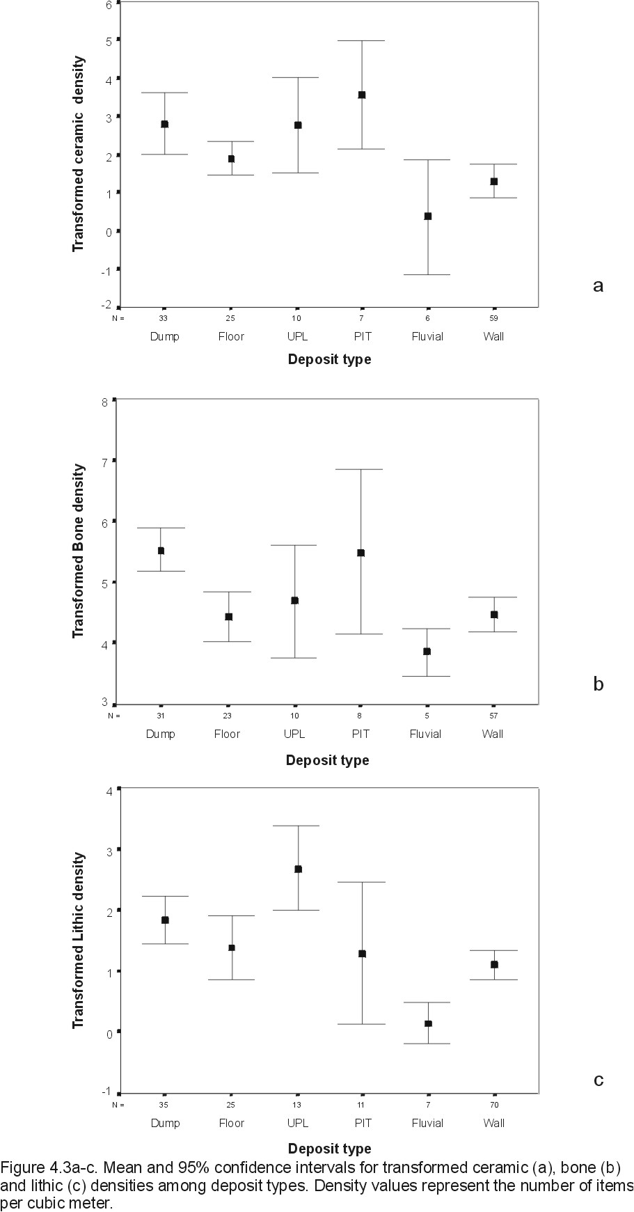
Combining these two groups of deposits together to facilitate comparison with other deposit types, I then examined how variation was distributed among the remaining deposit classes (excluding the burials [BUR] and column bases [CB] because of small sample sizes). Table 4.3 shows various density measures for the modified deposit types. To equalize the variance and satisfy the assumption of normality, I transformed each of the density variables using the natural logarithm of the density value; lithic densities were transformed using the natural logarithm of the density value plus one (i.e., Ln(1+DI) where DI is the individual lithic density for a deposit) as this produced more normal distributions than the simple logarithmic transformation. Error plots for transformed variables are shown in Figure 4.3a-c. Variances for all three variables are approximately equal and testing for homogeneity of variance using the Levene statistic showed that the transformed ceramic and bone densities can, in fact, be assumed to have equal variances (p=0.788 and 0.372 respectively). For transformed lithic density, the null hypothesis that all variances are equal is rejected (p=0.02); thus for this variable the assumption of equal variances is violated.
Examining the plots of the transformed variables shows several apparent patterns which were subsequently investigated statistically using one-way analysis of variance with the transformed variables. For the ceramics (Figure 4.3a), there are two basic groups: those with high densities of ceramics -- dumps, floors, pits, and the upper pottery layer -- and those with low densities of ceramics -- walls, and fluvial deposits. This was expected from the definition of the deposits themselves: fluvial deposits are generally devoid of larger artifacts due to the relative incompetence of water as a transport agent, while walls and wall-derived deposits should contain only ceramics included during construction as chinking or incidentally through subsequent collapse and redeposition. One-way ANOVA generates similar conclusions. None of the higher density deposits can be distinguished from one another, nor can the lower density deposits be distinguished from one another. However, only pits and dumps can be statistically differentiated from fluvial and wall deposits (p<=0.05). As the error plots show, the confidence intervals of floors and the upper pottery layer both extend in to the range of fluvial and wall deposits. Thus, there is a largely binary distribution of ceramic density within these deposits, with the highest densities associated with human transport mechanisms (dumps, floors, and pits) and as a lag deposit (UPL), and the lower density deposits associated with a less competent transport mechanism (fluvial) and the structural requirements of the initial deposit source (walls).
Bone density (Figure 4.3b) shows wider variation in density values, probably due to the relative lightness of bone with its consequent ease of transport. Dumps have a significantly higher average density than floor, wall, and fluvial deposits (p<=0.05). The wide variation in bone density of pit deposits reflects their varied sources. Two brick pits from Room 5 (DU's 8 and 9), for example, contained a great deal of fish bone relative to their volume indicating post-use dumping in the structure, while a series of clay layers from the bottom of the brick pit in Room 2 (DU's 6, 7, and 8) contained no bone at all. Dumps, with their relatively smaller variance, are the only deposit type that have consistently higher densities of bone than most other deposits.
Lithic density (Figure 4.3c) is more problematic to assess since lithic density tends to be more variable (due to the relative scarcity of stone artifacts) resulting in wider distributions. Some patterns are discernible, however, and can (with dubious confidence, due to the failure of the equal-variances assumption) be seen in the ANOVA tests as well. Fluvial deposits have predictably low densities of lithics, again due to the relative incompetence of running water as a transport mechanism. Pits have a wide distribution due to their varying modes of deposition, but generally have few lithics. The high mean density for pits is due largely to a single outlier, (1212/1072r05du09) which has a relatively large number of lithics (3) for a very small DU by volume (0.014 m3). The upper pottery layer has a high density of lithics overall and because of this can be differentiated by this variable from all other deposit types except for dumps which also have a fairly high lithic density. Otherwise, the deposits follow the same pattern as for ceramics and bone: dumps generally have a high lithic content and can be differentiated from lower-density wall and fluvial deposits.
Strictly in terms of artifact densities then, several patterns are noted. Wall, fluvial, and floor deposits have low frequencies of bone which distinguishes them from dumps. This is not unexpected since dumps are thought to represent food refuse deposits, while floors are assumed to be cleaned of macroscopic food remains. Ceramic densities tend to relate to the type of transport mechanism and the source of the deposits. The combined wall-derived deposits had few ceramics because walls contain few ceramics unless they were included as chinking or incidentally through collapse and transport of the sediments. Fluvial deposits contain few ceramics because water (at least in the amounts to be found flowing at Kom el-Hisn) is a relatively incompetent transport mechanism. The others contain varying amounts of ceramics but all higher than walls or fluvial deposits in large part because humans were directly involved in transporting them to their current positions.
Therefore, since artifact densities are shown to be non-randomly distributed among deposit types, and the observed patterns are readily explained by the sedimentary principles on which the deposits were created, I would argue that my depositional units have empirical justification. In analytic terms, I am safe in assuming that variation within deposit types is reflective of something other than depositional processes.
4.4 General depositional history of Kom el-Hisn
Certain kinds of deposits can be expected to be associated with different structures and in particular spatial locations within the site. By definition, floors are associated with enclosed structures (courtyards excepted, none of which are part of the excavated sample). Wall collapse deposits are closely associated with the location of the original wall, as are heavily decomposed wall collapse deposits. Where significant transport (usually by human agents) occurs, the spatial distributions of deposits is more complex. Fluvial deposits tend to form in enclosed basins bounded by mud brick walls or as natural or artificial topographic depressions. Because of the low relief at Kom el-Hisn fluvially transported deposits are not thought to have transported material very far from the source.
Dumps or refuse areas ('secondary' deposits of Schiffer 1972, 1983, 1987) are more complex in their spatial distributions. Many configurations of dumping areas have been noted both archaeologically and ethnographically. Living areas are regularly maintained and cleaned of accumulated refuse which is then deposited in locations away from the occupation area (e.g., Meehan 1982; Yellen 1977; O'Connell 1979). Dumping areas can occur in several different locations depending on the circumstances. Hayden and Cannon (1983), for example, describe contemporary Maya villages where trash is deposited in streets, peripheral dumps, or in nearby streams and ravines. Archaeologically, Dunnell (1983) found secondary refuse concentrated in a ring around the periphery of the Mayo site. Abandoned structures (both rooms and pits) as well as natural and artificial depressions are also ubiquitous locations of trash disposal. The spatial location of dumps is therefore partially controlled by the structural layout of the site itself.
Refuse disposal can also be culturally controlled. Hoffman (1974), in his analysis of trash disposal locations at the early Dynastic town of Hierakonpolis in southern Egypt noted several social factors that controlled the location of garbage dumps. Hoffman differentiated between elite, non-elite, and industrial disposal patterns which correspond to the social stratification present in Egyptian society. In non-elite areas trash is removed from living areas but may be only transported a short distance to nearby depressions or abandoned structures. Often, debris is used as leveling material on which to build new structures or within structures to provide a level surface for another occupation surface. In elite areas (both sacred and administrative) there is a deliberate attempt to remove all refuse so that the entire area is relatively clean of debris. After abandonment of these areas, refuse deposition can occur.
Industrial areas tend to have specialized sorts of debris reflecting the manufacturing activity. At Hierakonpolis, Hoffman recognized three separate industrial areas representing copper smelting, flint retouching debris found in a large sunken ceramic pot (interpreted as a butchery), and a circular structure that contained the debris of stone vase manufacturing. In all, Hoffman found "substantial differences in the treatment of architectural space and patterns of trash disposal" (Hoffman 1974: 48) and was able to discern distinct industrial, sacred-administrative, and elite and non-elite residential quarters.
The depositional sequence in a given location can show how the function of a structure and of a given area can change over time, for example, from habitation structure to a dump upon abandonment. The sequence in which the deposits occur reveals the basic site formation processes operating at Kom el-Hisn. Specifically, I hope to find any patterns in depositional sequences that indicate how the use of various structures change over time and the overall depositional sequence of this area of the site.
Initially, I tallied the kinds of deposits that each deposit type is bounded by -- what each deposit underlies and overlies -- and several patterns emerged. First, dumps are most often found on top of some form of wall collapse deposits (including decomposed and redeposited wall collapse). Of the fourteen dumps that had an underlying deposit (i.e., they were not at the bottom of the excavated stratigraphic column), nine (64%) were resting on some form of wall collapse indicating that dumping most often occurred after a building had already partially collapsed. In only four cases (29%) was the dump lying directly on a floor deposit. These four units -- 1235/1056, and Rooms 12, 17 and 23 -- showed no obvious spatial patterning, though they all contained moderate to high bone and ceramic densities relative to other dump deposits. All four were either at the top of the stratigraphic section and covered only by UPL or, in the case of 1235/1056 DU-12, were covered by later (First Intermediate or Middle Kingdom) deposits. In fact, the majority of dump deposits that occur in the Old Kingdom levels occur at the top of the section, generally overlain only by UPL. The exceptions are Room 6 DU-2, where the dump is only a thin layer between two episodes of wall collapse, and 1204/1060 where a redeposited wall collapse deposit (DU-3) was intermingled among the many redeposited dump deposits from that unit. Old Kingdom dumps, then, generally occur only after a period of time that allowed the room walls to collapse and were not overlain by other deposits.
Second, wall collapse deposits (including decomposed and redeposited wall collapse) preferentially occurred directly on top of floor deposits (14 of 25 cases, or 56%) and secondarily on top of dumps (8 of 25 or 32%); interestingly, only one of the dumps directly underlying wall collapse was itself resting on a floor (1235/1056 DU-12). This indicates again that dumping was generally not practiced before the walls of the room had already begun to collapse.
Floors and standing walls were generally built on top of wall collapse or heavily decomposed wall collapse, not often on brick platforms or redeposited wall collapse, and in only one case on top of dump material. This indicates that foundation deposits were, as noted above, generally carried out by knocking down and leveling existing walls, much as Giddy (1987) described at Ayn Asil.
The general sequence of deposits, then, followed the pattern Floor-Wall Collapse, followed by either dump material, UPL, or further sequences of Floor-Wall Collapse; rarely did dumps lie directly on top of floors. As Hoffman (1974) suggests, this may indicate that refuse was deposited primarily in either natural topographic depressions -- such as 1192/1035 and 1204/1060 -- or in abandoned room structures that had already begun to collapse. Since the majority of dump deposits in the main excavated portion of the site occurred on top of wall collapse deposits, this suggests that this part of the site was left abandoned for some period of time with limited refuse disposal occurring within the existing structures.
A possible explanation for this lack of dumping directly on top of floors may be found in the burials located in this area. Three adult burials were excavated along with several infant burials. All of the adult burials (one contained within Room 5, a second, excavated as Room 15, and a third excavated as Room 20) showed evidence of plastered coffins and the Room 15 and 20 burials were in specially constructed mud brick tomb structures. The burial in Room 20 had been cut into by (presumably) the sebakhin, and only the lower portion of the skeleton remained intact. All of these burials were intrusive into the existing Old Kingdom structures, as were the infant burials.
The ceramic assemblages from the deposits directly associated with the adult burials were all typical Old Kingdom wares. The depositional sequence in Room 15, for example, consisted of wall collapse and coffin plaster (DU-4) directly overlying the body and containing numerous ceramics, followed by a layer of typical dump material (DU-3) containing abundant bone, charcoal, and Old Kingdom ceramics. The remaining deposits (another layer of wall collapse and UPL) contained primarily Old Kingdom ceramics with two sherds of Middle Kingdom ceramics mixed in. This sequence suggests that the tomb was constructed after the room containing it (the large structure also containing Room 10) was abandoned, then left for some time for collapse of the coffin and surrounding walls to begin, at which time more Old Kingdom dump material was deposited on top of the burial.
I would suggest that at some time during the Old Kingdom, this part of the site was abandoned and used as a cemetery for both adults, including some relatively high-status individuals, and numerous child and infant burials. This would explain the relative absence of dump deposits directly on top of abandoned floors: the structures were allowed to collapse while the area was used as a cemetery and thus refuse was not dumped here. After some time, during which the previous habitation structures continued to decay along with the structures surrounding the burials, refuse dumping resumed with even the burial structures used as dumping areas.
If this is the case, then one would expect that most of the deposits identified as dumps within these structures -- those dumps not lying directly on top of room floors -- would not relate to the actual occupation of these structures, but to a period after the area's use as a cemetery and presumably from occupations in another part of the site. Certain non-room sequences of dumps, i.e., units 1192/1035 and 1204/1060, would presumably contain refuse from the period of occupation of the nearby structures.
After analyzing the depositional sequences throughout the site I have concluded that there are basically six sets of deposits involved in this part of the site. The topmost level, which I have designated as Level 0, comprises all material later than Old Kingdom date, including most of the Upper Pottery Layer, and those excavation units containing First Intermediate period and later ceramics. Beneath this, Level 1, are the dumps deposited after abandonment of this area and after it was used as a cemetery. Level 2 deposits are those directly associated with the adult burials. Level 3 deposits are those directly associated with the uppermost habitation structures, but excluding the intrusive burials and other deposits (mostly dumps) that were deposited after abandonment and partial collapse of the structures (comprising Levels 1 and 2). Below these main Old Kingdom occupation deposits are any older deposits, numbered sequentially down from Level 3; most units with lower deposits have only one lower level that was excavated (designated Level 4), and only one (Room 18) has more than one level below the main Level 3 deposits, designated Level 5.
The level designations are analogous to the chronostratigraphic units described by Stein (1987, 1990): the definition of a level is based on the time of the initial formation of the deposit. These units are meant to clarify the relationship of the deposits within a structure to the history of that structure; this is done to control for chronological variation that may occur within a sequence of deposits. For example, wall collapse deposits are tightly associated with a room's structure regardless of when the sediment moved from the intact walls of the room to collapse deposits inside the room. And, as the analysis in the previous section showed, little if any material was added during the time of collapse. The level associated with these deposits is chronological, indicating the period of construction and occupation. Other deposits, such as dumps, may only be associated with a particular room when they are deposited there which may be during the period the room was in use (i.e., the same chronostratigraphic unit) or at some later date and different chronostratigraphic period.
Consequently, wall collapse deposits are assigned to the same level as the walls making up a room and the room floor, since the materials making up these deposits were configured at roughly the same time: when the room was built and occupied. Dumps and other deposits that lie directly on the room's floor surface are also assigned to the same level as the floor and wall deposits, while dumps that were deposited later (i.e., after a period of deterioration evidenced by wall collapse deposits) are assigned to a different level. This may, of course, result in some instances of so-called 'reversed stratigraphy' (such as two Level 3 wall collapse deposits separated by a later level-1 dump deposit) and is a consequence of the definition of the units (chronostratigraphic rather than lithostratigraphic). The next chapter will describe each excavation unit in detail and provide a more detailed analysis of this proposed sequence.