2.0. Context and previous research.
The economic and settlement structure in which Kom el-Hisn operated can best be appreciated through an examination of the development of the Egyptian state from the first Neolithic farming villages through to the unification of the Dynastic state ca. 3100 BC. While the record for the late prehistory of Egypt is rather sparse in comparison to its neighbors of Canaan and Mesopotamia, there is sufficient evidence to establish the context in which the Old Kingdom developed. This development process is crucial for understanding those aspects of Egypt's settlement structure that are unique to the area.
2.1 Neolithic and Predynastic antecedents.
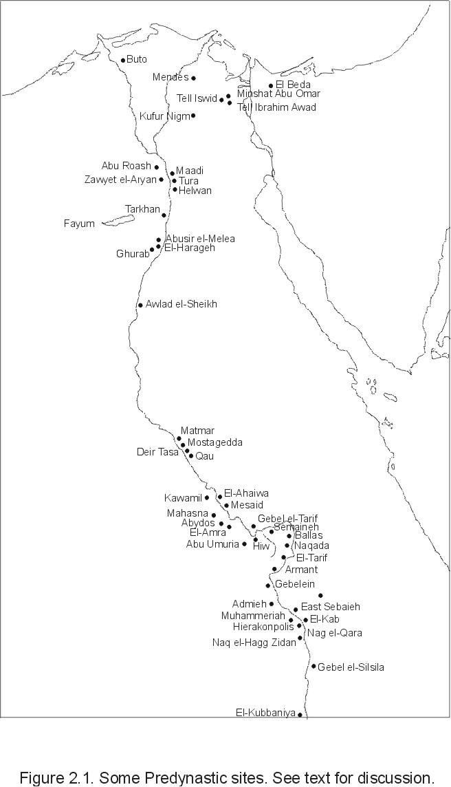
The first agricultural communities appear in Egypt in the Fayum depression, a desert oasis approximately 65 km southwest of modern Cairo (Figure 2.1). The earliest sites with secure dates are from the so-called Fayum 'A' sites initially described by Caton-Thompson (1926; Caton-Thompson and Gardner 1934) and by subsequent researchers (Ginter and Kozlowski 1983; Wendorf and Schild 1976; Wenke 1981; Wenke, et al. 1982, 1983, 1988b). The Fayum material consists primarily of scatters of lithic debris, faunal remains, and hearths. Though no secure habitation structures have been discovered to date (Caton-Thompson did note some apparent 'post holes' at Kom W), Caton-Thompson found storage pits with cereal remains preserved in them north of the Fayum lake. Significantly, these pits were located on higher ground away from the main settlement area, perhaps to avoid high lake levels. Radiocarbon dates place the Fayum occupations between about 5230 + 50 BC and to 4030 + 90 BC (Hassan 1985; see also Hassan and Robinson 1987).
The diet of the Fayum Neolithic peoples consisted of a wide variety of game animals including fish, hartebeest, gazelle, hare, and others, as well as numerous domesticated cattle, sheep/goat, and pigs (Brewer 1986; Caton-Thompson and Gardner 1934; Gautier 1976). Emmer wheat and 6-, 4-, and 2-rowed barley were also found. This subsistence pattern has much in common with the preceding Epipaleolithic (Qarunian) occupations in the same area, particularly in the abundance of catfish (sp. Clarias).
The generalized diet and widely scattered settlements, together with the lack of substantial domestic architecture, suggest semi-sedentary, perhaps seasonal occupations revolving around the availability of wild foods with part of the season reserved for collecting cultivated grains. Hassan (1988), however, has suggested that some of the larger settlements (e.g., Kom W and K) may have been occupied year round by a portion of the population. Hassan also has estimated the Fayum neolithic populations to be less than 200 people, possibly as few as 65 (1988:149).
Merimde Beni Salama (Eiwanger 1984, Junker 1929, 1930, 1932, 1933, 1934, 1940; Hawass et al. 1988), located on the western edge of the Delta, is slightly later than the Fayum but overlaps in time with it ranging from approximately 4800-4400 BC (Hassan 1985) and possibly from as early as 5000 BC to as late as 4100 BC (Hassan 1988:151). Compared to the Fayum, Merimde was a large site covering over 180,000 m2. Though dug in arbitrary levels it is possible to note several changes through time. In earlier levels the settlement consisted of sparsely scattered wind breaks or huts similar to the presumed habitation structures from the Fayum. Hearths were common in these structures, many of which were hollowed out in the middle for a cooking vessel; several large ceramic jars also were found sunk into the ground presumably for water storage.
Later levels provide evidence of denser habitation structures consisting of semi-subterranean adobe huts with others laid out in rows along a possible 'street' or in a double-ring configuration (Vandier 1952:117-119). The structures themselves consisted of walls built up of layers of mud or rough stone blocks plastered with a layer of mud, apparently roofed with some form of thatch, and ranging from 1.5-3.2m in diameter. Some burials were noted within the village itself, though not enough to account for the presumed population, possibly indicating some form of differential status; grave goods, however, were sparse. In terms of subsistence, the earlier layers indicate that the diet was similar to that of the Fayum: hunting, fishing, and some cultivation. Later inhabitants apparently depended more heavily on cultivated grains.
Culturally, there are many similarities between the Fayum and the lower levels at Merimde. Pottery was made of coarse, straw-tempered clay with shapes consisting mostly of bag-shaped jars and shallow flat dishes. Decoration was largely absent except for some red slipping; most had plain rough surfaces. The lithics represent a characteristic Neolithic bifacial flake industry which, apart from the addition of worked tabular slabs, is typologically are very similar to the Nabta-Bir Kiseiba assemblages (Holmes 1989; Wenke et al. 1988b). The two are so similar in lithic content that they have been referred to as the same cultural tradition even with the significant differences in size and apparent density of occupation.
However, it is apparent that in later levels Merimde was a much more substantial and permanent settlement with a great amount of time and labor going into constructing the habitation structures and supporting a much larger population, estimated by Hassan (1988) to have been between 1300 and 2000 people. A greater degree of functional differentiation also may be apparent in the structured layout of the dwellings and the integration of granaries within the village itself.
Also near Cairo is El Omari, a collection of settlements and cemeteries approximately contemporary with the later Merimde levels. The habitations are, again, mostly oval huts although Vandier (1952:156) notes that some may have been semi-subterranean. Some larger areas apparently were enclosed by reed fences suggesting animal pens. Burials were located within the habitation areas, though some used earlier storage pits; all had few grave goods. Both the pottery and lithics are similar to those found at Merimde.
Roughly contemporaneous with these northern sites are a series of occupations in Middle Egypt that form the Badarian (ca. 5000-4000 BC). These sites are known primarily in the area around the Badari district including Matmar and Mostagedda (see Figure 2.1). The Badarian was initially thought to be confined to this area only, but typical Badarian artifacts have been found at Armant, Hierakonpolis, and Wadi Hammamat (Hayes 1965:147; Kantor 1965:4; Trigger 1983:27), thus showing some regional cultural coherence not apparently extant in the Delta at this time. While Badarian sites are most often cemeteries a few settlements have been excavated. At Deir Tasa, Gabra (1930) found a series of habitations similar to those in the Fayum and the earlier levels of Merimde: small huts or windbreaks associated with hearths and storage pits. As Hassan (1988) notes, these storage pits were much larger (up to 2.7m in diameter and up to 3m in depth) than those at either Merimde or the Fayum indicating a greater reliance on agricultural produce.
Badarian ceramics tend to be of higher quality than contemporary northern forms, consisting of simple shapes but with thinner, harder walls, with combed or highly burnished surfaces. Copper and other materials were apparently imported, such as turquoise from the Sinai, and cedar and other woods from Syria (Trigger 1983:29).
Caton-Thompson and Brunton surveyed the entire Badari-Matmar-Mostagedda area and reported up to 40 habitation and 40 cemetery sites. Most of these were similar in structure to Deir Tasa and, with the exception of Hemamiah, all had relatively thin occupation layers, indicating a less sedentary settlement pattern than that at Merimde. In terms of subsistence, the Badarians were relatively more reliant on agriculture and animal husbandry than their northern counterparts, yet wild game is still present in substantial quantities. Functionally, these settlements differ somewhat from the Delta sites in that several contained substantial accumulations of animal dung indicating that domesticated animals were allowed to forage in nearby fields rather than grazed over a wide area. This may, however, be a result of ecological factors (the flood plain is narrower in this section of the river) rather than some cultural difference.
Up to this point, about 4000 BC, there is relatively little in the archaeological record to differentiate the Neolithic people from their late Paleolithic ancestors. They still rely on wild game for a variable part of the diet (a larger part in the Delta and Fayum) and still live in insubstantial, only partially sedentary habitations. However, some intrasite functional differentiation already can be seen, most of which relates to the increasing reliance on agricultural products. Little in the way of social differentiation is discernible either architecturally or in differential burial practices (with the possible exception of Merimde; see also Anderson [1992] for possible evidence of inequalities in Badarian burials). Settlements appear to represent independent, functionally redundant units, with each providing all necessary subsistence activities in and around the main settlement areas.
Substantial changes occur in the 4th millennium which lay the foundations for the early Egyptian state and may indicate the sort of settlement patterns and economic structures that form the basis for the later dynastic pattern. This period traditionally has been delineated into two or three phases, the Amratian-Gerzean or Naqada I, II, and III, the Gerzean roughly coinciding with Naqada II and III.
The Amratian/Naqada I (ca. 4000-3500 BC) is in many ways a continuation of the Badarian. First defined by Petrie at el-Amrah (Petrie 1902) and later refined by Caton-Thompson at Hemamieh (Caton-Thompson 1928), the Amratian is distinguished from the Badarian primarily on the basis of changes in artifacts. The Black-topped red ware so characteristic of the Badarian continues into the Amratian but certain other decorative elements become common. White cross-lined vessels appear, as well as scenes depicting people and animals in naturalistic settings. While some (e.g. Baumgartel 1955) have posited a Mesopotamian influence for these elements, others (e.g., Trigger 1983) suggest that the apparent similarities are far too general to specify such influences.
Recent work in the Ballas area (Hassan 1981) reveals numerous occupations dating to around 3750 BC, some up to 3 ha. in extent. Structural remains are similar to earlier versions (pole-thatch huts), but many are made of blocks of mud and/or stones. All contain hearths and storage pits, some contain burials, and animal pens (indicated by accumulations of dung in restricted areas) are common. Analysis of artifact distributions indicates that these various settlements form a larger community, though this seems to be a cultural affinity rather than a functional one (Hassan 1988:155). Similar settlements composed of roughly circular huts made of mud and rubble were also located by Caton-Thompson at Hemamieh. Thus, although in many ways the Amratian is a continuation of the earlier Badarian, a shift to more substantial domestic architecture is common by at least 3750 BC, and some kind of larger cultural units have formed.
It is during the latter half of the 4th millennium (Gerzean/Naqada II-III) that substantial changes take place both at the site and regional levels. Dwellings at this time shift from insubstantial pole-thatch huts to typical squarish mud-brick buildings common throughout the middle east and SW Asia. Hoffman (1980) found several buildings at Hierakonpolis (Localities 29 and 49A). The house at Location 29 was roughly rectangular (roughly 4 X 3.5m), semi-subterranean (ca. 45-80 cm deep), plastered with mud, and had freestanding walls of mud brick and brick debris. A roof was supported by eight pillars, and the structure itself contained an 'oven', a large storage pot, and a large upright ceramic slab possibly functioning as a heat barrier.
Similar developments occurred in the Delta. Maadi (Menghin and Amer 1932, 1936; Rizkana and Seeher 1984, 1985), near modern Cairo, is a large site, ca. 18 hectares in area, with cultural deposits up to two meters thick and has been dated to the latter part of the Gerzean (ca. 3300-3100 BC). It contains dwellings consisting of oval huts or windbreaks which are concentrated in the center of the site; there are, however, several circular to oval subterranean dwellings dug up to two meters deep with stairways leading down into them. Special storage areas were located on the periphery as in the Fayum and at Merimde. Some of these storage pits were large pottery jars buried up to their necks, many of which contained carbonized grain, while others contained valuables such as basalt vases, and carnelian beads.
Artifactually, the Gerzean reflects a number of internal developments and also clear evidence of influences from outside of Egypt. While the familiar Black-topped red ware and Red Polished wares show considerable continuity with earlier forms, several ceramic forms with no progenitors in Egypt appear. Influence on ceramic form was both ideational and a result of direct importation of finished products. Wavy ledge-handled pots were produced in Egypt but stylistically borrow their design from Early Bronze forms in Canaan (Amiran and Gophna 1992; Gophna 1992; Porat 1989; Trigger 1983). Other pottery was directly imported from Canaan to Egypt such as at, for example, Hierakonpolis (Adams and Friedman 1992), Buto (Kohler 1992; von der Way 1987, 1988, 1992), and Maadi (Porat and Seeher 1988). Egyptian-made pottery has also been found in Canaan at Taur Ikhbeineh (Oren and Yekutieli 1992), 'En Besor Oasis (Gophna 1992), and elsewhere (Redford 1986, 1992). Much of this Gerzean interaction with Early Bronze Canaan resulted from Egyptian-controlled administration and commercial networks in Sinai and southern Canaan in which at least a portion of the inhabitants were Egyptians (Amiran and Gophna 1992; Brandl 1992; Gophna 1992; Porat 1992). There is also some suggestion that Canaanites were in residence at Buto (Pittman 1996:17; von der Way 1987, 1992) similar to the Minoan presence at Tell-el-Daba/Avaris in the 12th Dynasty (Bietak 1995, 1996). These contacts are not necessarily new to the Gerzean but may reflect an elaboration of trade networks that were already in place during the Amration (Moorey 1987, 1990; Schmidt 1992a).
Ceramic production also reveals a certain amount of craft specialization and an increase in the distribution of standard ceramic forms. Earlier ceramics were produced from local clays found along the banks of the Nile (Nile mud). However, many Gerzean forms were produced using clays high in calcium carbonate and which are found in restricted outcrops in the limestone hills bordering the Nile valley (e.g., Qena and Ballas). The wide distribution of standard forms of ledge-handled jars made from these clays indicates mass production at one or a few centers. Though the specific manufacturing sites have not been found, Hoffmann (1980, 1982; Hoffman, et al. 1986) has posited Hierakonpolis as a major ceramic producer for much of Upper Egypt. The supposed introduction at about this time of the slow wheel in manufacture may also be related to increased production (Baumgartel 1970:488; Lucas and Harris 1962:369). However, the possibility of some other functional and/or technological factor involving the use of these clays should not be ruled out (Dunnell and Feathers 1990, Feathers 1990).
Copper implements, both hammered and cast, become much more prominent in the Gerzean. Maadi was engaged in some degree of copper production and may have obtained raw material via the Sinai (Baumgartel 1955:122) though the extent of this production and trade is in question (Rizkana and Seeher 1985). Egyptian-made stone vessels have also been found in Early Bronze age Knossos (Warren 1995) and the Minoans copied Egyptian forms in local stone (Warren and Hankey 1989). Cylinder seals, a distinctly Mesopotamian invention, also find their way to Egypt at this time. As with the pottery, Mesopotamian influence on Egyptian seals took many forms. The earliest seals of Mesopotamian manufacture were found in Gerzean/Naqada IIb graves (Arkell and Ucko 1965:154; Moorey 1987: 37; Podzorski 1988). The idea of marking the clay enclosing jars with seals of some sort as a means of identification and administrative control owes its conception in Egypt directly to Mesopotamia (Pittman 1996:16). Besides the imported seals, Egyptians also copied much of the basic iconography from the Mesopotamian varieties. For example, lions and bulls (not present in earlier Egyptian representations) become common on Egyptian seals and are combined with strictly Egyptian flora and fauna such as the ibis and hyena (Collon 1987,1990; Pittman 1996; Porada 1984; Redford 1992). Both Pittman (1996) and Moorey (1987, 1990) suggest that the earliest imported seals were obtained as status symbols through long-distance trade via Canaan, thus their placement in graves.
The trade in exotic items was probably controlled by a small ruling elite from the few large centers in Upper (Hierakonpolis, Naqada, Abydos) and Lower (Buto, Maadi) Egypt who used these objects as prestige items to demonstrate their wealth and power (Hoffman 1979; Kuhrt 1998; Moorey 1987). Kuhrt (1998:133) suggests that competition for exotic goods and materials may have enhanced the positions of those who controlled the trade routes by which these items entered the country, which could explain the importance of those upper Egyptian settlements lying at the end of wadi routes through the eastern desert (Hierakonpolis, Naqada, and Abydos). Helck (1962) felt that trade with Mesopotamia was mediated by Canaan and the Levant via the Delta. Silver, obtained from Anatolia, was most likely acquired via the Mediterranean in the Delta region, and Redford (1992) notes that the close contact dynastic Egypt maintained with Byblos also probably extended back into the Predynastic. Recent work at Buto shows Predynastic levels containing colored clay cones closely resembling similar cones used on temple facades at Uruk and perhaps imported from there (von der Way 1987, 1988, 1992). Thus, it is entirely possible that foreign influences in the Delta region have been markedly underestimated.
Others favor a more direct sea route around the Arabian peninsula and the Red Sea. It is perhaps not coincidental that the two largest centers in upper Egypt, Naqada and Hierakonpolis, are not only situated at the head of wadis with direct routes through the eastern desert to the Red Sea, but are also positioned to extricate gold from the eastern desert regions, one of Egypt's possible trading products. For example, the Egyptian name for Naqada, opposite Koptos, meant (literally) the 'gold town' and in later times Egyptian gold was distinguished from the Nubian variety by the designation 'Gold from the Desert of Koptos' (Trigger 1983:39).
Overall population may have increased in Gerzean times; certainly specific towns such as Hierakonpolis underwent major demographic changes, but whether this is due to a net increase in the population as a whole or just the growth of some settlements to the detriment of others remains an open question. While regional data is lacking regarding these demographic changes on a large scale, the pattern observed at Hierakonpolis may indicate the sort of overall changes in site function and placement during the Gerzean. In late Amratian - early Gerzean times (ca. 3800-3500 BC) Hoffman, et al. (1986) describe several types of settlements present in the Hierakonpolis region from small herding camps to large habitations covering 7 ha. or more. Both inter- and intrasite differences are noted, including separate habitation, trash disposal, industrial, and mortuary zones within settlements. It is at this time that a division of labor is evidenced by specialized pottery production and other products (ground stone vases, basketry, linens) and an administrative structure to manage the production and distribution of goods.
During the middle/late Gerzean (ca. 3500-3400 BC) Hierakonpolis apparently became the regional capital of an upper Egyptian state or incipient nation-state (Kemp 1989). At this time the regional population, previously scattered among several different kinds of settlements, coalesced into a single settlement centered at Nekhen. Hoffman et al. (1986) suggest this was for defensive purposes. Hierakonpolis at this point resembles the typical urban complex of Mesopotamia with specialized structures for religious activities and what is apparently a fortified enclosure.
It is unclear what sorts of changes took place outside of the central settlement at this time. It seems clear that the entire population did not reside in the main urban complex as, minimally, agricultural activities had to have taken place away from the central urbanized area. T. Eric Peet excavated what is apparently an outlying settlement at Abydos. Peet produced a schematic plan of the site in which some degree of spatial differentiation could be observed within a roughly circular plan (Figure 44 in Hoffman 1979:151; cf. Dunnell 1983). Midden was found around the perimeters of the village suggesting perhaps trash dumping, with a grain-parching kiln located in the northeast corner. Just within this perimeter zone were hearths where, it is presumed, food preparation took place. Within the center of the site Peet found what he took to be 'the remains of huts built of wattle and covered with mud' (Peet 1914:2). While the structure of the habitations is largely conjectural (Peet only found a single stratum consisting of mud and artifacts) it still illustrates the degree to which portions of the populace still resided in simple, decidedly non-urban dwellings.
2.2 Predynastic summary.
Several trends took place in the Predynastic that may indicate the structure of the Dynastic Egyptian settlement pattern. In earlier periods (Neolithic and early Predynastic) the overall settlement pattern consisted of numerous, functionally independent farming villages composed of small, light habitation structures, and variably dependent on wild game. The trend over this early period is towards greater internal differentiation within each settlement, as habitation structures become more permanent and perhaps as agriculture becomes a more prominent part of the diet. This is seen, for example, at Merimde where later levels have a more orderly arrangement and the storage pits are separated from the main habitation areas.
There is some degree of cultural interaction between settlements but the nature of this interaction is unclear. Artifactually, this is indicated by the strong similarities in lithic content between the Fayum and Merimde for example, and also by the distribution of certain ceramic wares in the south (Badarian). The layout of settlements may also indicate some kind of cultural homogeneity. Those in the north tend to put storage pits away from the main habitation with burials within the habitation areas, while in the south the layout is reversed. I suspect that these interactions were probably not primarily functional (sensu Dunnell 1978c) as the common traits seem to be more stylistic in nature (such as pottery decoration).
Later in the first half of the fourth millennium certain settlements became larger and more functionally diverse both internally and with respect to other settlements. Because of the relative paucity of excavated smaller sites it is difficult to determine overall settlement patters, though Kemp (1977) has suggested that it was a primate distribution with numerous smaller villages up and down the Nile with at least two (and possibly three, including Abydos) large concentrations at Naqada and Hierakonpolis. It is perhaps significant that defensive walls became common at this time indicating some degree of (violent) competition between larger settlements.
In the late Predynastic (Gerzean) interaction became functional in nature in the form of centralized production and distribution of certain necessary goods and services such as ceramics. This may have been the point at which the minimal functional unit changed scale from the individual or kin-group to aggregates of settlements. It is within these larger aggregates that individual settlements are functionally differentiated and must interact in order to survive. Social differentiation is apparent in the disparity in quantity and quality of grave goods and distribution of luxury trade items.
It is within this context that the settlement structures characterizing Old Kingdom Egypt developed. It is clear from the preceding that some degree of functional differentiation had evolved by Early Dynastic times (e.g., Maadi) and that certain fundamental aspects of earlier patterns had changed. While the record for smaller settlements is extremely sparse in relation to the larger central towns, there is evidence that a shift occurred in the placement of many of these smaller agricultural villages during the late Predynastic. As Kemp (1977) notes, in those locations (mostly in upper Egypt) where such smaller sites have been examined in some detail -- especially around the Matmar-Etmania area, Naqada, Armant, and Hierakonpolis -- a number of smaller settlements along the desert edge were entirely abandoned by the 1st Dynasty. Brunton and Caton-Thompson (1928) interpreted this as a shift to the flood plain proper in order to become more involved in managed flood plain agriculture, though there is little evidence of these valley floor settlements remaining.
Thus, one could argue that the process of unification was less a process of overlaying a state structure on top of existing independent agricultural communities than it was a basic shift in the way in which individual settlements operated and organized around natural flood basins (Butzer 1976). It should be noted, however, that most of the foregoing relies on data gathered in the valley proper, not in the relative terra incognita of the Delta.
2.3 Old Kingdom context.
The preceding section indicates that significant changes took place in the functioning of individual settlements in the late Predynastic. The overarching theme of the Predynastic is one of increasing interdependence among settlements, eventually resulting in a centrally controlled state structure. However, the degree to which settlements remained interdependent into the Old Kingdom and beyond is the subject of much speculation (e.g., Bietak 1979b; Kemp 1977; von Pilgrim 1997; Wenke 1997).
The process of unification may help to explain how much of the existing Predynastic settlement structure carried on into the Old Kingdom. The unification myth is a powerful concept in Egyptian mythology. The king lists of the Turin Canon and Manetho both begin with Menes as the first king to unify Upper and Lower Egypt into a single entity. The Abydos king list also begins with Menes and provides only the names of kings who ruled over a united Egypt, omitting those during the Intermediate Periods (Kuhrt 1998:125). In addition, the royal titulary, names, and symbols of the king further strengthened his role as the embodiment of the unified country. The king was often portrayed wearing the combined crowns of Upper (white crown) and Lower (red crown) Egypt, or a crown supplanted with the vulture (Nekhabet) of Upper Egypt and the cobra (Wadjet) of Lower Egypt. The king was also referred to by his nsw-bity name, 'King of Upper and Lower Egypt', written using the sedge (Upper Egypt) and the bee (Lower Egypt).
The actual process by which unification took place is unclear. The general unification story, as represented most famously on the Narmer Palette, is of an Upper Egyptian king conquering a unified Lower Egyptian kingdom, thus uniting the two lands. However, as the preceding section has shown, there is little evidence for any sort of united kingdom in the Delta even though some degree of cultural integration was present.
The king lists provide only partial clarification. The list produced by Manetho was probably a reproduction of a New Kingdom (1550-1080 BC) tradition, as were the Turin Canon and Abydos lists (Kuhrt 1998:127). These sources show Menes as the first king of the 1st Dynasty who presumably united the two lands himself. The Palermo stone, however, was composed in the 5th Dynasty (2494-2345 BC) closer to the time these events supposedly took place. This document lists names of kings occurring before the 'unification', suggesting that unification had taken place before Menes and that Menes was simply restoring a divided kingdom. However, yet another list, the 'Saqqara tablet', produced by a scribe of the 19th Dynasty (1306-1185 BC; Kuhrt 1998:127-128) begins with the sixth king of the 1st Dynasty, suggesting that perhaps there was some resistance to the status of the earlier kings.
A general model of the unification process is provided by Kemp (1989) and echoed by Kuhrt (1998). According to this model, a number of 'proto-kingdoms' developed around major centers in Upper Egypt, namely Hierakonpolis, Naqada, and Abydos. These kingdoms competed with other for access to agricultural wealth and exotic foreign goods (from Mesopotamia and also Nubia), and through competition and consolidation a single polity came to control all of Upper Egypt. It was at this time that some form of intrusion into the Delta occurred. The evidence for this 'conquest' of Lower Egypt is largely inferential and based on textual sources and limited excavations in the Delta. There does seem to be a fairly rapid replacement of Lower Egyptian ceramic forms with Upper Egyptian types. However, recent detailed excavations at Buto have shown that Upper Egyptian forms had already begun to filter into the Delta in Naqadan times, with a gradual increase in Upper Egyptian types over time while Lower Egyptian forms gradually disappeared (von der Way 1992).
Consequently, unification might be more properly interpreted as the relatively gradual development of an increasingly homogenous Upper Egyptian kingdom eventually asserting its dominance over the scattered communities of Lower Egypt. In this context, Menes could represent a particularly important figure in a long line of rulers that eventually led to the Egyptian state, and the traditional separation of Upper and Lower Egyptian kingdoms may be a later ideological construction meant to solidify and reinforce the status of the ruler.
Once Egypt was united into a single entity the state rapidly assumed many characteristics that were to survive for almost three millennia. The main occupations at Kom el-Hisn date to the 5th and 6th Dynasties (ca. 2494-2181 BC) and coring suggests that occupation extended back into the 4th Dynasty (2613-2494 BC) as well (Wenke et al. 1988a:13). It was during this time, especially the 4th Dynasty, that many of the monumental funerary and temple complexes in and around Giza were constructed. Thus, Kom el-Hisn was occupied during the height of Old Kingdom prestige and power.
Authority during this period was centered clearly and unambiguously on the king and his immediate family. The concept of royal divinity was perhaps strongest at this time with all power and authority emanating directly from the king (Wilson 1951b:79). The king himself was thought to embody the state, to preserve secular law and order, and maintain ma'at, the state of truth, balance, and order. Below the king stood several levels of administration, the officials of which derived all of their authority from their relation to the royal family. Kemp (1983) divided Egyptian society below the royal family into three categories: literate administrators, who drew their authority directly from the king; professional subordinates serving these administrators (artisans, scribes, etc.); and a largely illiterate peasant class (Kemp 1983:81). In many cases the structure and duties of the administrative class are not well attested. In some sense, the number of titles that a person had and the closeness of these titles to the king indicated that person's status within the hierarchy. In many cases, the function of these positions is clear, such as 'state granary official' or 'state treasurer'; in others, the title is more obscure and may represent purely ceremonial offices, such as 'elder of the portal' (Kemp 1983:80). In any case, the acquisition of as many titles as possible as a life goal is indicated by the prominence of titles in the tombs of officials; presumably, the more titles one acquired, the more privileges and wealth one would accrue through income-producing land and other resources that came with the office.
Many of these officials resided at the capital of Memphis, but administrative authority was also dispersed throughout the country. The structure of this administration seems to have commandeered regional administrative units ('nomes') that may have existed for hundreds of years prior to the Dynastic state. A governor was placed in charge of a nome, and managed the affairs of the nome in the name of the king. Whether the governorate was a hereditary position or a revolving post is unknown, but in many cases individual talent seems to have played a role in the offices one could achieve. The autobiography of Weni, an official from the 6th Dynasty, shows the various duties a talented official could accrue over his lifetime. Among other titles, Weni was the 'Warden of Nekhen' (Hierakonpolis), 'Mayor of Nekheb', ' custodian of the storehouse', 'Overseer of the robing room', and eventually the governor of Lower Egypt (Lichtheim 1975:18-19).
Much of this bureaucracy was geared toward the collection of taxes that supported state projects such as tomb and temple construction and the financing of military expeditions. State income was derived from land and other resources (including foreign trade) owned by the king and also from a country-wide tax levy (Kemp 1989:236) that obtained both goods and labor. In return, the government redistributed certain goods and services in the form of food rations and centralized production of many craft goods, such as ceramics. However, while the state certainly had a pervasive influence, private commerce was not unknown. Private land ownership is known from the Old and Middle Kingdoms (Kemp 1983:81; 1989) and Eyre (1987) interprets various tomb paintings as indicative of local markets where various crafts and personal services were exchanged.
Egypt during the Old Kingdom also extended its influence outside of its borders. Mining for turquoise and copper was carried out in the Sinai, and a city was established near Buhen that processed copper and may have acted as a trading outpost for goods arriving from Nubia and sub-Saharan Africa. Operations to the north in Canaan involved the import of timber and other goods from Byblos, and several extensive military campaigns, one involving Weni (above) who led an expedition composed of conscripts from Egypt and Nubia (Aldred 1987:117; Lichtheim 1975:19-20).
Thus, Old Kingdom Egypt is characterized by a strong central government centered on the king and his court, an extensive system of taxation to support state projects, and an administrative class that derived its authority directly from the king but whose loyalties were directed in part at accumulating personal wealth. The bulk of the Egyptian population that supported this state structure is, to some extent, invisible epigraphically, shown only incidentally in tomb paintings and in offering texts performing the work required to support deceased individuals in the afterlife. This population was dispersed throughout the country in a variety of towns and villages of which little is known either textually or archaeologically. The Predynastic sequence shows a trend towards functional interdependence among some of the larger excavated settlements, but the question remains whether this interdependence carried over into the Old Kingdom.
Epigraphic scholars have generally assumed that most rural communities were largely self-sufficient in basic goods and services, yet the immense quantities of apparently highly standardized artifacts (especially ceramics) found in tombs, and the apparent similarity of settlement and mortuary ceramics suggests a high degree of centralization and specialization over craft production. Trigger (1983, 1993) has contrasted the Egyptian state structure with that of contemporary Mesopotamian city-states. Wealth within the latter was distributed among a number of large, fortified urban city-states and among several competing interest groups within each urban center. These urban centers tended to be extremely large compared to other settlements (a primate distribution), contained a diverse population from all socio-economic classes, and interacted with the local populations through a market-based exchange system (Adams 1981).
Contrasted with the city-state structure of Mesopotamia, Trigger defined Egypt as a 'territorial state' in which wealth and power tended to be hierarchically arranged at national, provincial and local levels with the largest centers occupied primarily by administrative officials and the craft specialists that supported them. The bulk of the population was dispersed in smaller communities throughout the territory of the state giving rise to the largely rural character of Egyptian society (Wilson 1960). Rather than a market-based support structure, Trigger argues that the population was related to the central government in an appropriative fashion through rent, taxes, and corvee labor requirements while local populations largely supplied their own goods and services through regional markets. Indeed, this scenario has a good deal of textual support. Many texts refer to highly complex censuses for taxation purposes, in some cases (e.g., the Palermo stone [Edwards 1971:38]) making these censuses key events for describing regnal years. Goedicke (1967:56, 72), for example, relates how revenue could be assessed on the basis of "canals, wells, water bags, and trees."
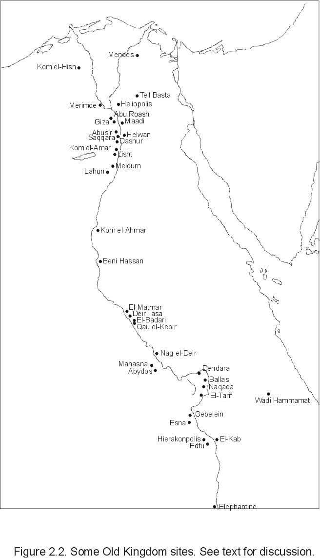
Kemp (1983:81) further argues that the archaeological record suggests a complex and extensive local marketing system that was not controlled solely by a government redistribution system and included local production of copies of exotic foreign goods. State concerns also were not immune to entrepreneurial activities. For example, millions of animals were mummified and offered in cult centers which no doubt provided a need for entire industries devoted to raising and selling sacrificial animals (Brier 1994:213). The cult of Imhotep centered near Saqqara (Figure 2.2) provided a robust business selling mummified animals to visitors as offerings, particularly ibis which were contained in small conical pots. Ray (1976:41) describes a priest named Hor who attempted to regulate the marketing of these ibis mummies since many of them contained only a few bones wrapped in rags to make it look like an ibis. Visitors to the various archaeological sites in modern Egypt can attest to the lure that such tourist dollars offer the local population.
Analyses of the structure of administrative titles and cemeteries indicate that during Early Dynastic and Old Kingdom times there was a high degree of centralization. Various authors (e.g., Kanawati 1977, 1980; Strudwick 1985) have noted an increase in both the number of officials and an apparent devolution of power away from the central authority towards regional powers near the end of the Old Kingdom. This suggests that the unification of the northern and southern kingdoms resulted in a shift of power from the regional authorities (nomes) to a highly centralized administration centered around the king and his immediate family. How this may have affected relations between already existing settlements is unclear since it generally is assumed that the nome, or regional governorate (perhaps defined by natural flood basins), was maintained as the basic economic unit from Predynastic times onward.
Certainly, the central government had a large role in the placement and function of new settlements. Many special-purpose towns are known, several of which (e.g., Buhen) functioned as trading and/or defensive outposts. Other settlements were planned and built for religious and/or funerary purposes, the so-called pyramid towns and "pious foundations." Pious foundations involved a subtle relationship with the central government whereby grants of land were issued for the direct support of cult centers either within the local community or at central temple and funerary complexes and were exempt from taxation and other labor requirements. Tomb inscriptions imply that these
were especially prominent in the Delta region and as Kemp (1983:111) suggests, may indicate that the Delta had a much closer, less autonomous relationship with the central government than the rest of Egypt. However, Moens and Wetterstrom (1988) note that no direct archaeological evidence for such sites exists, and are thought to exist only through funerary inscriptions. It is also unclear whether the groupings of pious foundations were built around existing settlements and to what degree they were integrated into the local economy.
Many officials or members of the royal family owned private estates from which they derived income, but it is unclear whether these estates were granted by the king for services performed or were established estates prior to the 1st Dynasty. Trigger (1983), in fact, suggests that older Predynastic patterns of land holding were not interfered with by the king. Such private estates were subject to taxation and corvee labor requirements and no doubt provided much of the income and work force for various state projects. However, the relationship between the central government and these private estate holders could be fairly complex. For example, many of these estates may have been owned by the office holder rather than as strictly private property. Furthermore, since taxation was so extensive, many of these estates could be converted to pious foundations and therefore exempt from much taxation to the benefit of the owner and his descendants.
Placement of settlements also was determined to a large extent by ecological factors. As noted by Baines and Malek (1980) the nomal structure of Pharaonic times corresponds quite closely with natural flood basins and the location of reconstructed branches of the Nile in the Delta. The underlying geology also plays a significant role in the placement of Delta settlements. Most larger Delta sites are located on topographic rises composed of middle Pleistocene coarse-medium alluvial gezira sands. In an extensive survey of part of the northeastern Delta, van den Brink (1987) found these gezira deposits to be very important in the location of settlements, positing that they were placed there to avoid high Nile floods but remain as close as possible to agricultural lands. The highest parts of the gezira often had cemeteries placed on them while the lower sides were used for habitation. Van den Brink also showed that a majority of settlements were located along waterways. Bietak (1979b:102) also notes that Delta sites tend to be placed along waterways and at the junction points of land routes across the Delta, especially where main roads meet waterways (e.g., Tanis, Mendes).
In sum, the placement of settlements during the Old Kingdom was influenced strongly by topological and ecological factors and existing settlement/economic patterns, but there was also a degree of central planning involving economic/trade and religious factors. Within this context one can define several different kinds of settlements based on their location, architectural structure, and presumed function with the larger society.
The structure and function of settlements differed across several types of settlements, which may be broken down into five basic types (Wenke 1997; Bietak 1979b): the 'capital' city of Memphis; large walled towns functioning as regional centers or as frontier outposts and trading entrepots; temple and pyramid towns; and small provincial villages. Of these, Memphis and the small villages are the most poorly known. While Old Kingdom remains from Memphis are relatively rare due to their being covered by subsequent occupations, corings indicate that Old Kingdom Memphis was a large settlement and may have been functionally distinct from other settlements rather than being simply larger. In later times Memphis functioned as a major administrative and religious center, and its placement was in no small part due to its location at the junction between Upper and Lower Egypt. Van den Brink's (1988) survey of a portion of the eastern Delta located dozens of small settlements, but these have not been excavated extensively.
The remaining larger towns and cities are better known, but again much of the Old Kingdom remains have been covered/destroyed by later occupations or lie well below the current water table. Generally, only portions of any given site have been excavated in any detail so the overall structure within these settlements is not well known. Several features are apparent across some settlement types and some distinctions can be made based on the apparent function of these towns within the overall economic and social system.
A second and third set of settlements consists of large walled towns functioning as either regional centers or as frontier outposts or trading entrepots. Most of these, located primarily in Upper Egypt, are characterized by large, fortified enclosure walls composed of some combination of mud brick and/or stone. These enclosure walls are not usually of strictly geometric pattern (e.g., Hierakonpolis) leading Kemp (1989:138) to suggest that they were not centrally planned constructions, but grew out of local needs and direction such as topography and preexisting settlement structures. Some form of initial pre-planning is in evidence at several sites but it is clear that as the settlements grew in size the enclosure walls were either extended or rebuilt to accommodate the larger populations.
At Edfu (see Figure 2.2) for example (Alliot 1935; Bruyere, et al. 1937), the main settlement area was enclosed by an initial mud brick wall and later a second wall was added encircling the previous wall with habitation structures filling the space between. Outside of these main occupation areas were a cemetery with numerous mud brick mastabas and an ancillary village to the west. Eventually, a second wall was constructed that enclosed this ancillary village as well, the south side of the wall utilizing the earlier mastabas as part of the wall's structure. The situation is much the same at Elephantine (Bietak 1979b:108; Kemp 1977, 1983:99; von Pilgrim 1997) where the main occupation was situated on a granite ridge and enclosed by a mud brick wall which followed the local topography and contained at least one stone-lined gateway. There was also an extramural settlement to the west which was enclosed by a later wall.
Similarly, Ayn Asil in the Dahkla Oasis underwent three major construction phases with the first and last each having its own enclosure wall specifically built for it. In Phase I, a large, approximately square, installation defined by a massive mud brick enclosure wall was constructed, the shape of which Giddy (1987) suggests is a reflection of direct planning by the central administration. After a period of haphazard settlement (Phase II), the whole area was leveled, former occupation structures filled in with rubbish, mud brick rubble, sand and mud brick masonry, and two new enclosure walls built: a smaller one to the north which followed an irregular path (perhaps enclosing previously existing outlying settlements), and a much larger well-built wall (which Giddy again uses to argue for some kind of central planning) around the main settlement area.
The function of these walls seems purely defensive in nature since many are very massive and they tend to be located on the margins of the territory controlled by the Egyptian state. In the Delta such walls are not well attested, though this may be due to the activities of sebakh (fertilizer) diggers.
The overall structure of Old Kingdom settlements is difficult to determine since large sections of them are either obscured/destroyed by later occupations, lie well below the water table, or have simply not been excavated to any large extent. Some of the most extensive information on settlement structure come from the pyramid/temple towns of the Middle Kingdom and some from the Old Kingdom. While these, especially the former, are not necessarily directly applicable to other settlement types of Old Kingdom Egypt they do provide some clues.
Three pyramid towns of Old Kingdom vintage serve as starting points. The Neferirkara temple complex at Abusir (Borchardt 1909) consists of an enclosure wall surrounding the temple buildings with the spaces between filled with nine house structures. The houses presumably were the residences and/or administrative offices of the priestly inhabitants who seem to have been resident for only short periods of time, perhaps one month, and had permanent residence elsewhere either in the local area or closer to the central administration. The layout of the rooms indicates that maintenance was not organized (or funded) centrally, but solely through the resources of the temple complex itself. This local support of mortuary temples is also indicated through textual descriptions of priests donating funds to the restoration of temples and other historic monuments.
At Giza, further structuring of the building layout may be seen at the village adjacent to the tomb of queen Khentkawes (Hassan 1943). The village extended in an L-shaped plan east of the tomb and consisted of a series of interlocking rectangular rooms. The way room blocks were laid out seems to suggest that the arrangement was determined more by security and/or privacy considerations rather than ease of access. Room blocks usually consisted of a central room with 2-3 ancillary rooms attached to it. Two of these rooms contained circular grain pits (one had a single pit, another had four), and the southern or back room in each block served as the kitchen area as indicated by ovens and ash deposits.
The Valley Temple of Menkaura (Reisner 1931) demonstrates further the non-planned organic nature of growth in some Old Kingdom settlements. The village itself accreted over time and was built on the rubble of the earlier temple. In some cases, parts of the temple were demolished to create new structures. Grain storage structures were again found in several rooms and were generally clustered towards the north end of the complex. Kemp (1989) suggests that the area still functioned as the center for Menkaura's mortuary cult but that over time the activities tended to become more private and hidden. This ad hoc and hidden nature of the settlement also is reflected at the valley temple of Sneferu (4thDynasty) at Dahshur (Fakhry 1959). In that case, the limestone temple complex within a mud brick wall was gradually filled in with residential structures for approximately 15 households for a population which Kemp (1989) estimates to be about one hundred.
In contrast to the relatively ad hoc nature of Old Kingdom pyramid towns are the highly structured urban complexes of the Middle Kingdom (Arnold 1989). The rigid structuring of Middle Kingdom settlement plans appears to reflect the extreme government-centered nature of the Middle Kingdom in general. The most well known of these Middle Kingdom towns is the valley temple complex of Senusret II (Kahun; ancient name: Hetep-Senusret) near Lahun at the entrance to the Fayum Depression (Petrie 1890, 1891; Petrie, et al. 1923; David 1986). This is the largest known of the pyramid towns and large portions have been excavated. The large size combined with textual evidence indicate that Kahun functioned as more than a mortuary complex. Two groups of papyri were found, one group from the temple area having to do with temple functions, and the other within the town proper dealing with the business of the surrounding community. Many of these texts refer to the land holdings and agricultural business of the priests and temple, but it is unknown whether private landowners also did business in the town.
The settlement itself is roughly square (384X335m) and is surrounded by a large wall with an inner wall separating a strip in the west from the main settlement areas (purpose unknown). The layout is strictly orthogonal or grid-like and is divided into room blocks. Each room block consisted of several parts, basically a central residential core surrounded by groups of chambers. The actual functions of these buildings are determined from the excavations themselves and from house models such as those from the Middle Kingdom burial of Meket-ra (Winlock 1955). The main residential unit was composed of a central entrance court or portico leading to the main residential chambers. One ancillary building was a granary; others functioned as cattle sheds, butcheries, bakery-breweries, and weaving and carpentry work areas. Each room block was probably the residence of a single family together with their supporting workers (soldiers, scribes, household servants) which may be why each room block has its own set of granaries instead of a single centralized granary.
Contrary to the Old Kingdom model, Kahun represents direct planning and maintenance by the central authority for a permanent, year-round population. The more self-sufficient nature of the settlement is indicated by the much larger population involved (ca. 3000-5000; Kemp 1989:155), the larger range of activities in evidence, and the fact that the community maintained its own temple separate from the mortuary complex.
Similar arrangements are found at Abydos (Wegner 1998), the pyramid complex of Amenemhat III at Dahshur (Arnold 1980, 1982; Arnold and Stadelman 1977), Abu Ghalib (located a few kilometers NW of Cairo which may be twice the size of Kahun [Larsen 1935]), and Tell el-Daba (Bietak 1979a, 1985, 1995, 1996) in the eastern Delta. All exhibit orthogonal plans oriented along compass points. Abu Ghalib also functioned as a center directing shipments of goods from the Delta to Upper Egypt and as a specialized bead manufacturer.
Other relatively well-known settlements from the Middle Kingdom are the fortified towns and garrisons in Nubia. Buhen (Emery 1963, 1965, Emery, et al. 1979) contains a large heavily fortified inner settlement and an outer, less well fortified area. The inner area, the main fortress, was heavily protected by a large (ca. 9m high, 150X138m) brick wall and contained a temple, garrison buildings, and several blocks of interlocking rooms and workshops as at Kahun. The outer area (ca. 450X150 m) had a much smaller protective wall and, though hardly excavated at all, seems to have been sparsely populated containing at least one cemetery area to the west. A similar arrangement is found at Shalfak (Reisner, et al. 1967) near the Second Cataract.
Middle Kingdom settlements thus appear to have been directly planned and maintained by the central administration in much closer fashion than their Old Kingdom counterparts. However, these are all special-purpose sites with, for the most part, specific functions relating to temple and mortuary complexes or border outposts with military or trade functions.
The Old Kingdom remains at Buhen (Emery 1963), lying north of the Middle Kingdom fortress, consist of several rectangular rooms enclosed within a rough stone wall. The layout of the site is distinctly non-grid like. The site seems to have functioned as a trading outpost and the presence of copper slag and ingot molds suggest ore processing was also carried out (Gayar and Jones 1989). Old Kingdom Buhen also seems to have been directly maintained by the central administration due to the large numbers of seals and papyri directly naming high officials and kings. The occupations also do not appear to have extended beyond the Old Kingdom.
At Hierakonpolis (Fairservis, et al. 1972; Quibell and Green 1902,) the overall pattern of the interior buildings tends to follow that of the enclosure wall, itself composed of several straight sections following an irregular path. In the occupational areas numerous different types of buildings were identified. Domestic buildings were identified by the presence of hearths, ovens, large buried storage pots, and manos and metates (Hoffman 1972). The presence of slag-filled and slab-lined hearths indicate that substantial industrial activities were taking place, the products of which, in certain cases (pottery) were intended for distribution beyond the local area.
The main excavated portions of Ayn Asil pertain to the Phase II occupations. The excavated area is located at the northeast corner of the fortification wall near a gate. The walls of the buildings tend to follow the outline of the enclosure wall. One section was apparently used as a stable identified by a buildup of laminated organic floor materials. Other rooms had hearths, burned faunal remains, and lithic debris; but these remains were generally located in corners of rooms and so insubstantial as to suggest small temporary squatter's camps. Nevertheless, all of the excavated rooms in this area comprise a single set of related habitation structures, though the excavator notes that the specific functions of each room are as yet unknown (Giddy 1987:188). These Phase II occupations tend to reflect a local ad hoc use of the space as indicated by numerous renovations and various small, insubstantial occupations within rooms and corridors.
The sequence of habitation at Ayn Asil seems to reflect an initial planned fortified settlement, possibly directed by the central authority (Giddy's Phase I). This was followed by a period of haphazard occupation, renovation, and various processes of drift sand filling parts of the site (Phase II). This may reflect something of an abandonment by the government, which Giddy relates to the sequence of Middle Kingdom Buhen where a permanent community grew up around the fortress during the 13th Dynasty. During the Phase III occupations, the entire Phase II occupations were leveled and a new (largely unexcavated) pre-planned urban complex was built, in some areas using the infilled sand as foundation deposits.
2.4 Summary of architectural development.
During the fourth millennium B.C. the bulk of the Egyptian population lived in small, self-sufficient farming villages composed of small, semi-permanent huts, and were dependent to some degree on agricultural products and domestic animals with some component of wild game and fish. Functional differentiation within and among communities was minor until the Predynastic, though specialized production of some commodities (e.g., Maadi) and trade (e.g., Buto) served to differentiate some communities from each other. Increasing differences in grave goods, especially in Upper Egypt foreshadowed the extensive mortuary cults of the later dynastic state.
With the institution of the central government and the unification of the north and south, some rearrangement of the settlement pattern and intra- and intersite functional differentiation no doubt occurred, though the evidence for this is scarce due to a lack of excavated samples of communities of different sizes. Those Old Kingdom and Middle Kingdom settlements that have been reported have the following general attributes:
1) An enclosure wall, which may be either regular and planned, grow to follow local concerns and topography, or some combination of the two, and may be either purely defensive or perhaps more for internal security.
2) Tightly packed mud brick buildings and streets, often following the contours of the enclosure wall.
3) Functional differentiation of the interior structures, including residential areas, industrial or workshop areas, and temple precincts. These may be separated into distinctly different areas of the site (e.g., Hierakonpolis), or several functions may be grouped into residential blocks, the latter apparently more characteristic of the Middle Kingdom.
The concept of Egypt being a 'civilization without cities' is perhaps misleading given that many of these sites are of substantial size and embody numerous activities within their walls. Still, because of the relative paucity of excavated smaller rural settlements as well as some larger towns -- especially in the Delta -- that are not directly involved in either large mortuary or temple complexes, the overall pattern of settlement structure and function in Old Kingdom Egypt is still largely unknown.
For example, some of the settlements discussed above seem to be relatively self-sufficient in terms of goods and services produced (notably Kahun), but their relationship with the surrounding villages, and the central government, is unclear. Especially at the smaller Old Kingdom sites (e.g., Abusir), where only temporary residence and administrative functions were performed, the residents must have interacted with the local inhabitants in some way. Did they purchase needed goods and services directly? Were products directed there from some central location? Were local lands owned by the priesthood and temple (e.g., Kahun) involved in local trade and exchange networks? Did different pyramid towns have differing degrees of self-reliance? And to what degree were ordinary agricultural villages self-sufficient in basic good and services?
Questions about the overall settlement pattern and function of the many and varied settlements in Old Kingdom Egypt must be answered by detailed excavations of many different kinds of sites throughout the Delta and Nile valley, from large urban settings to small agricultural villages. Only by using this kind of holistic regional approach and describing the various functional configurations of individual sites can one then integrate knowledge gained from textual and other sources regarding the various administrative functions of the central administration with purely archaeological information gained from excavation.
2.5 Kom el-Hisn: Context and previous research.
2.5.1 Geographic context.
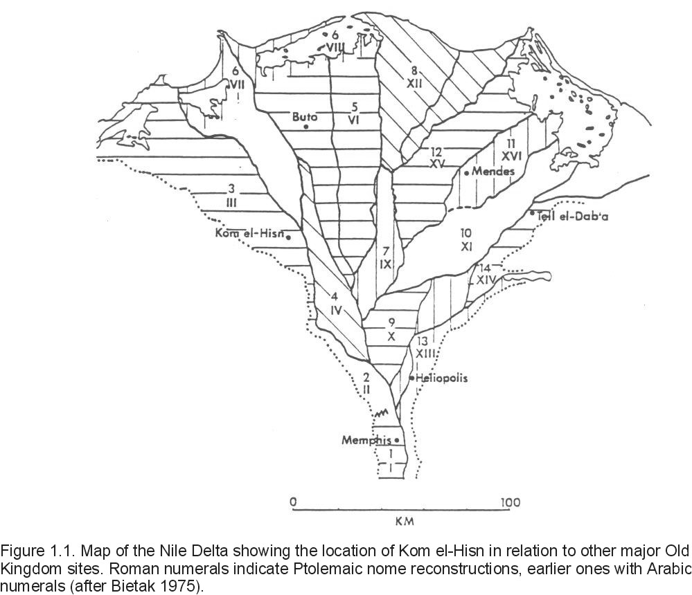
The site of Kom el-Hisn lies approximately 100 km northwest of Cairo and about 10 km southeast of the village of Dilingat near the western margin of the Delta (see Figure 1.1). The Rosetta branch of the Nile flows approximately 14 km to the south-southeast and several canals lie within a few kilometers of the site. The surrounding area consists of agricultural plots interspersed with small brackish ponds, drainage canals, and swampy areas. Soils tend to be sandy and not particularly productive agriculturally (Wilson 1955) and the overall topography of the region ranges from zero to a few meters above sea level.
Geologically, the basic sedimentary units are Quaternary sands and gravels overlain by Holocene fluvial sediments ('Nile mud'). The main structural feature of Kom el-Hisn is the gezira sand on which the cultural deposits rest. Extensive coring of the area in 1984 and 1986 revealed that the gezira sands extend in a general north-south direction for about 700 meters long and 400 meters wide (Buck 1990) and at a maximum of 7 meters above sea level (a.s.l.). The deposit consists of well-sorted medium sand with a mean grain size of 1.5-2.5 phi and may be several meters thick. The origin of this gezira sand is somewhat controversial and may represent either stabilized sand dunes (Said 1981) or remnants of Pleistocene sands and gravels ('turtlebacks') deposited when sea level was higher (Sandford and Arkell 1939; Ball 1939). Turtlebacks tend to be rare in the western Delta and much more common in the eastern Delta (Said 1981), but Fortau (1915) shows the maximum eastern extent of these deposits passing near Kom el-Hisn. Analysis of the core data collected at Kom el-Hisn may militate in favor of an aeolian origin. The gezira has a very high sand fraction (90-98%; Buck 1990:60) with a very small silt and clay component, and the particle size characteristics are very similar to other known dune deposits found in the Delta. A single radiocarbon date of 11,344 + 241 BP (Wenke et al. 1988b) also places this deposit at a time when sea level was low.
The Nile muds that lie atop the gezira sand are generally poorly sorted silts and coarse clays with a high organic content and form the agricultural base of the Delta. Presumably, most of the base sediments comprising the cultural deposits consist of transported Nile mud and gezira sand (Rosen 1986). The cultural deposits themselves lie stratigraphically in direct contact with the underlying gezira. Midden deposits are exposed primarily in the southern part of the site and extend under the agricultural fields to the north and northeast, and to the south are interspersed between layers of Nile mud.
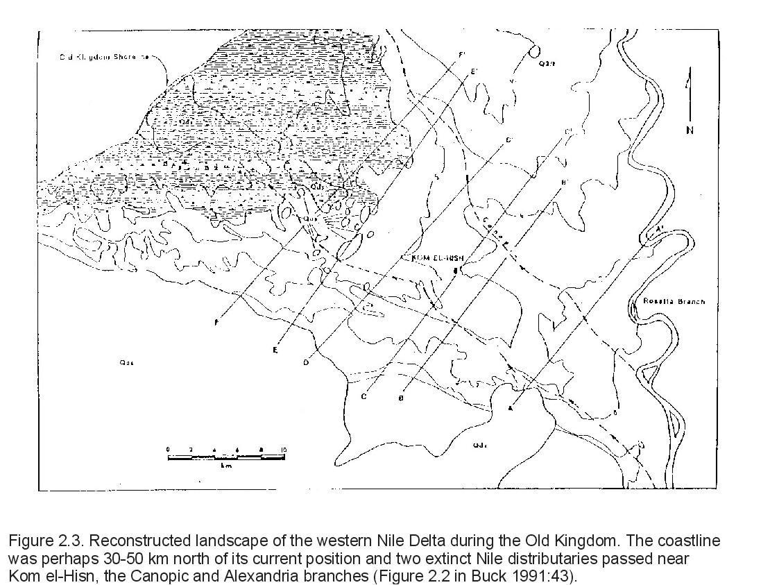
The location of the site is at least partly due to these geologic factors. Recent surveys indicate that Old Kingdom settlements tend to be found along major waterways, such as primary Nile branches and distributaries, either for irrigation purposes or for ready access to communication and trade. While there are only two primary distributaries in the Delta today, as many as nine have been identified to have existed. The largest of the eastern distributaries was the Canopic branch which flowed near Naukratis in the 6th century B.C. and may have existed in Old Kingdom times (Figure 2.3). Egyptian Geological Survey maps and geological profiles show a good correspondence with historical information regarding the Canopic branch. Another smaller distributary, the Alexandria branch, is shown by Toussoun (1922) flowing to the west of Kom el-Hisn along the western margin of the Delta and emptying into Lake Maryut. Since these distributaries migrated over time it is difficult to determine the exact locations of the distributaries at the time of Kom el-Hisn's occupation in the Old Kingdom without extensive coring and dating of the deposits, but it seems clear that at least these two branches and possibly other large canals were within a few kilometers of Kom el-Hisn.
The gezira deposit itself also no doubt contributed to the placement of the site. These gezira deposits are topographically higher than the surrounding deposits and often represent 'islands' in a sea of Nile mud. As noted in the preceding section, a survey by van den Brink (1987, 1988) of part of the northeastern Delta revealed that these topographic high points were important in the determination of settlement placement, possibly as a refuge from high Nile floods and also perhaps to minimize the agricultural land used for settlement.
2.5.2 Previous research.
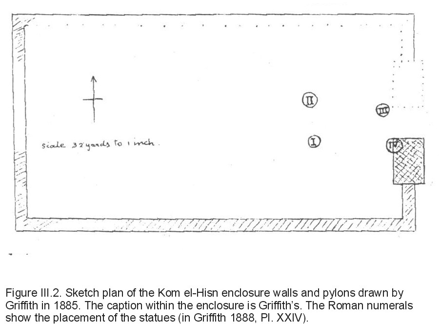
Prior to the current excavations, archaeological work at Kom el-Hisn (reviewed in more detail in Appendix III) has been sporadic and not usually related to the Old Kingdom remains. Petrie (1886) noted the presence of a statue of Ramesses II, and
Griffith (1888) produced a plan map that showed a brick enclosure wall with the remains of a pylon at its eastern end and four statues of Ramesses II (see Figure III.2). Griffith's estimate of the size of the site, about a mile by a third of a mile, agrees well with the current estimate allowing for destruction due to the sebakhin. Neither the temple complex nor the pylons noted by Griffith are visible today.
The only other extensive excavations were conducted by Hamada, el-Amir, and Farid who excavated almost a thousand burials on the northern gezira portion of the site in the 1940's (Hamada and el-Amir 1947; Hamada and Farid 1947, 1948, 1950). The majority of graves have been dated to the latter part of the First Intermediate period but some Middle Kingdom and New Kingdom burials also were found (Brunton 1947). Many of these graves were simple inhumations with a few pots present but others were relatively rich in contents and construction quality, especially those from the New Kingdom.
The other major monuments of note are the limestone tomb of Khesu-wer, a Middle Kingdom official under Amenemmes (Amenemhat) III (Silverman 1981), and a collection of dressed stones to the far north of the site which have been variously described as a double tomb structure or simply blocks piled from the adjacent fields.
Textually, Kom el-Hisn has been associated with Yamu (im3w), the capital of the third nome of Lower Egypt (Griffith 1888:78), and is known from texts since the 5th Dynasty. Inscribed Middle and New Kingdom monuments at Kom el-Hisn associate Yamu with the goddesses Hathor and Sekhmet (Montet 1957; also see Appendix III). This apparent association with cattle may extend further. Cattle form part of the names of four Lower Egyptian nomes and cattle cults were apparently widespread in the Delta (Kees 1961; Montet 1957) and cattle frequently appear crossing Delta marshes in Old Kingdom tomb scenes.
2.5.3 Current research.
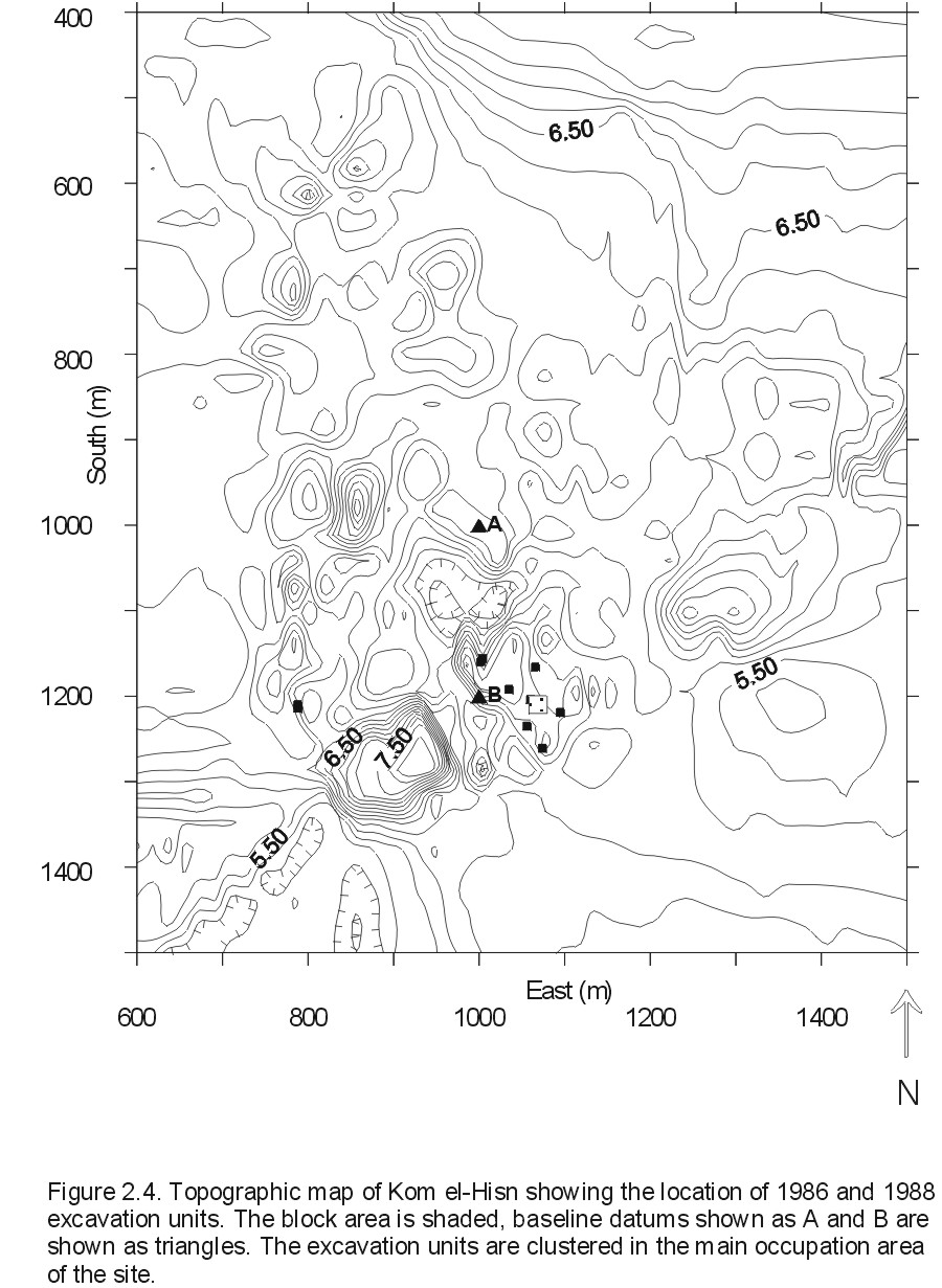
The current excavations on which the present research is based were conducted over three seasons, 1984, 1986, and 1988. The main occupation areas are located in the southern portion of the site (Figure 2.4). The majority of the site is covered by a layer of coarse salt-encrusted sediment with abundant ceramics (hereafter, the Upper Pottery Layer or UPL) which is thought to be a lag deposit resulting from sebakh digging. Mud brick architecture is found throughout the main midden within a few centimeters of the surface.
Excavation proceeded in two stages. The first stage was carried out in the first two seasons. In 1984 several randomly selected 1 X 2 meter test pits were excavated along with two trenches and another 1 X 2 meter pit that were arbitrarily chosen based on surficial architectural features. Based on the results of these excavations, in 1986 a stratified random sample design was used to excavate a number of 2 X 2 meter pits. In addition, a 72 m2 trench (the 'block area') was cleared and excavated to reveal architectural relations, and two further step-trenches were excavated to examine topographic features. The purpose of this stage of excavation was to obtain a statistically valid sample of artifactual remains and to clarify the overall structure of the site as far as possible.
In 1988 a third set of excavations was conducted to clear a wider area and expose more architecture. The main portions of this excavation were located adjacent to the block area excavated in 1986 since the architecture in this area was particularly well preserved and close to the surface. Two other areas were also cleared to reveal the architectural features, one a few meters northwest of the main block area (containing Rooms 17 and 20) and another in the far western portion of the site abutting agricultural fields (Rooms 22 and 23). The purpose of this stage of excavation was to clarify the architectural relations found in the previous two seasons and to obtain samples with known architectural contexts.
Published result thus far, mostly from data collected from the 1984 and 1986 seasons (Buck 1990; Moens and Wetterstrom 1988; Wenke, et al. 1988a; Wenke and Redding 1985, 1986), indicate the following. First, the majority of cultural remains are of Old Kingdom date and are largely undisturbed by later occupations. A small area of Middle Kingdom remains is located in the southwestern end of the site and two burials thought to be of First Intermediate age are also intrusive into the Old Kingdom architecture. The date of the occupations is based primarily on ceramic types. Most forms are known from other Old Kingdom occupations at Giza, Saqqara, and other Lower Egyptian sites, and specifically represent wares common in Dynasties 5-6. No evidence of ceramic production, such as kilns or slag, has been found. Radiocarbon dates (Wenke et al. 1988a) also correct to Early Dynastic or Old Kingdom times. Epigraphic material came mostly from the Middle Kingdom portions of the site, but several fragments of Old Kingdom date were also found.
Second, the structure of the site indicates mostly domestic architecture extending over at least 900 m2. No architectural use of stone was found. A large enclosure wall seems to ring at least a portion of the site, evidence for which appears near the modern village in the southwestern end of the site. Wenke et al. (1988a) suggest that an administrative or religious sector was located in this southwestern area, now covered by the modern village. Structurally this would make Kom el-Hisn similar to other Old Kingdom centers where these functions were performed in a restricted, and possibly walled, area of the town. There seem to be at least two major building episodes represented for the Old Kingdom, and probably three. Earlier structures were apparently leveled with rubble before rebuilding rather than utilized in later constructions.
The artifacts analyzed thus far indicate basic domestic activities. Typical 'bread mold' ceramics, fire-blackened (cooking?) jars, and shallow bowls suggest food preparation and storage. The lithic component consisted of almost equal parts of chipped and ground stone tools. The majority of debitage and finished tools were blades and sickle blades, respectively. The character of the blades and the almost complete absence of cores or manufacturing debris indicates that most lithic reduction took place off-site and that either blade blanks or prepared cores were imported into the site. About 15% of the ground stone tools represent grinding implements (manos or metates) and the remainder, with the exception of some flakes of limestone, granite, and alabaster, seem to be reworked pieces of these grinding implements.
Taken together, the vertebrate remains indicate a mixed diet of domestic (sheep/goats, pigs, cattle) and wild (fish, hartebeest) animals. Mammal bone dominates the faunal assemblage numerically (identified specimens), by weight, and by meat yield as part of the diet, but all other major vertebrate classes are present except for amphibians (Redding ND). The majority of the mammalian remains are from sheep/goats and pig. Age and sex distributions, while tentative, indicate that pigs were eaten before maturity while sheep/goats had a bimodal distribution with some individuals killed as juveniles and others in late maturity. The remainder of the vertebrate remains primarily consist of animals present in the surrounding area, such as catfish (Clarias), Nile perch (Lates), various species of bird (e.g., teal), and game animals such as hartebeest (Alcelaphus). Curiously, few remains of domestic waterfowl -- geese and ducks -- which are characteristic of Egyptian villages of all periods, have been found.
Cattle bones are rare in the Kom el-Hisn assemblages and this fact, together with evidence from the botanical remains, suggests that at least one function of Kom el-Hisn was as a specialized cattle producer. The absence of cattle bones implies that cattle, if present, were not eaten on site but exported elsewhere, perhaps to religious or administrative centers. In addition, Moens and Wetterstrom (1988) note that the distributions of four general classes of plant remains -- cereal straw, field weeds, reeds and sedges, and fodder plants -- differ from those at other habitation sites in Egypt. Fodder (e.g., clover, vetch) composes almost 27% of the remains thus far analyzed and suggests that the animals were fed in pens on specially raised crops and only allowed to browse in the open seasonally if at all. Little evidence of sheep/goat dung has been found and it is thus argued that the majority of these remains came from cattle dung used as fuel.
In fact, much of the evidence indicates that Kom el-Hisn may have had strong ties to the central government. The absence of production facilities for basic goods and the similarity of ceramic types to those found in administrative and mortuary contexts at Giza, together with the evidence of specialized cattle production indicate a smaller degree of self-sufficiency than is generally supposed for Old Kingdom Egypt. Whether Kom el-Hisn was initially settled either as a pious foundation, a directly administered arm of the central authority, or if it simply developed that way, is unclear.
Thus, several questions involving the basic function of Kom el-Hisn locally and with respect to the central government remain unanswered. How self-sufficient was Kom el-Hisn in terms of basic subsistence? Was it integrated into the regional economy or distinct from it as a governmental institution? What was the range of activities carried out at the site and how were they organized spatially? Did these functions or their spatial distribution change over time? The somewhat limited extent of the data gathered thus far allow only limited answers to these questions. However, this research should provide the outlines of a basic functional model of Kom el-Hisn's functional complexity that may be compared with other sites.